Increased SME investment in digital transition could add €8.3 billion to the Irish economy

Digital Business Ireland (DBI), the country’s largest representative body for digital and online businesses, has today issued a major new report on supporting the further growth of digital commerce in Ireland. The report, titled ‘Taking Digital Commerce in Ireland to the Next Level’ includes and an economic assessment which estimates that doubling the average level of digital investment by Irish SMEs could add €8.3 billion to the Irish economy.
Digital commerce in Ireland is booming, driven by Irish consumers, with Ireland among the European leaders in terms of online purchasing. This level of consumer demand offers a real and tangible opportunity for businesses in Ireland. In 2024, 37.9% of small enterprises were engaged in digital commerce (CSO) – the second highest in Europe – yet many SMEs have still not reached the level of digital maturity required to compete effectively.
The report argues that businesses should be seeking, on an ongoing basis, to upscale their digital maturity and enhance their digital commerce capabilities. The report also sets-out a new Digital Maturity Model for Ireland that cover five levelsFoundational, Operational, Embedded, Transformational, Exploratory.
Following the publication of the report, Victor Timon, Chair of Digital Business Ireland, said: “The reality of digital transition is that it is a task that is never completed. The tempo of change never slows. For all the progress we have made as an economy, the accelerating pace of digital innovation and the unprecedented opportunities offered by AI means there is always new ground to travel and there is always another level to be reached. Digital Business Ireland’s core message is that all businesses should be striving and supported to move up to the next level of digital maturity. But to achieve this there needs to be transformative uplift in business investment in digital transition in Ireland.”
The report recognises that government and state enterprise agencies including Enterprise Ireland, Fáilte Ireland and the Local Enterprise Offices have played a vitally important role in supporting businesses on their digital journey.  However, the report comes against the backdrop of data which shows that while 74% of Irish SMEs have reached a basic level of digital intensity, only 39% have achieved an advanced level (EU Digital Decade). At the same time, the percentage of Irish SMEs investing in digital transition is falling (ESRI).
The report identifies a number of recommendations for future business supports from both Government and industry. Among the key recommendations are:
  • The introduction of a second, higher-value tier of the Grow Digital Voucher to support businesses in Ireland to invest in next-level digital commerce capabilities, building on the discontinued Enterprise Ireland Online Retail Scheme.
  • The introduction of targeted tax measures, such as Accelerated Tax Credits, to incentivise ongoing business investment in next-level digital commerce capabilities.
While the Grow Digital Voucher represents an important measure to support Irish SMEs at the Foundational and Emerging levels of digital maturity with meeting the costs of digital transition, the current €5,000 grant limit is not sufficient to incentivise SMEs to invest in the types of technologies and capabilities set out in the report.
Feedback to Digital Business Ireland from its member companies and partners has indicated that the previous Enterprise Ireland Online Retail Scheme had proven effective and that a similar scheme should be reintroduced to help business to meet the costs of ongoing investment in upscaling their digital retailing capabilities. Digital Business Ireland also believes tax measures could prove an accessible and effective fiscal approach to incentivising and unlocking business investment in digital transition and the adoption of AI.
The report also discusses how digital advertising is essential to the success of digital commerce, offering businesses, especially SMEs, an accessible and cost-efficient means of reaching interested consumer and growing their sales. The report recommends that the Irish Government actively champion policy positions at an EU level which seek to preserve and strengthen the ability of business in Ireland to use personalised ads. The report also recommends that Government conduct an assessment of the value of digital advertising to the Irish economy and jobs.
The report sets out a number of case studies of Irish-owned brands and retailers who have developed their digital commerce presence with the support of digital agencies who members of DBI:
  • Golden Discs – supported by Truffle Hog
  • Elephant Living – supported by Core Optimisation
  • Lily O’Briens – supported by All human
The report also includes a case study of the Strategic Banking Corporation of Ireland (SBCI) who are a DBI partner and who are playing a leading role in supporting Irish businesses seeking to access finance to invest in digital transition.

Dublin Fire Brigade invests in location intelligence

Esri Ireland, the market leader in Geographic Information Systems (GIS), announces that Dublin Fire Brigade has deployed a new digital mapping system designed to improve emergency response, strengthen firefighter and public safety, and enhance how critical resources are allocated across Dublin city and county.

Ireland’s largest fire and rescue service, Dublin Fire Brigade was founded over 160 years ago. It provides fire, rescue, and emergency ambulance services 24 hours a day, 365 days a year, to Dublin’s 1.5 million citizens. It recently established a new Organisational Intelligence Unit with a key goal to optimise the use of location-based information to effectively manage fire risks and help keep communities safe.

Built using Esri’s ArcGIS technology, the new digital mapping system brings together operational data, such as the locations of fire stations and historic fire incidents, with third-party data – including census and population health information – for the first time.

Enhanced insights support increased safety for both the public and firefighters by raising awareness of buildings in Dublin with fire safety issues – such as inadequate means of escape, building defects, or over-occupancy. Using the technology, Dublin Fire Brigade can now map this information and put effective response plans in place that take known issues into account.

What’s more, the technology is enabling Dublin Fire Brigade to carry out more targeted community fire prevention activities by focusing citizen safety campaigns on specific vulnerable groups, especially in locations that are experiencing clusters of dwelling fires. It can easily see where fire safety efforts are still needed to reach at-risk communities, as well as contextual data such as concentrations of smokers or elderly people.

In addition, Dublin Fire Brigade is using Esri’s ArcGIS technology to identify optimal locations for new fire stations as Dublin continues to expand, as well as to ensure that aerial fire appliances are strategically located to reach the tallest and highest-risk buildings.

Dublin Fire Brigade plans to make the system widely available across varying departments within the organisation to enable more strategic planning and informed decision-making.

Rob Howell, Station Officer, Organisational Intelligence Unit, Dublin Fire Brigade, said: “It has been a really successful collaboration. The consultants at Esri Ireland have a high level of expertise, both in terms of their GIS knowledge and their project management skills. This technology gives us the ability to target our fire prevention strategies – we can deliver campaigns in the right locations to reach the most vulnerable people and have the biggest impact in terms of community fire prevention. Equally, we have to consider firefighters’ health and safety as well as that of the general public and, by being better informed, we can improve our responses to incidents and keep our responders safe in fires and other emergency situations. The potential for location intelligence in the fire service is absolutely huge and has a big role to play in our future.”

Gareth McBride, Customer Success Manager, Esri Ireland, said: “Dublin Fire Brigade is continuously evolving the fire service to meet the needs of Dublin’s residents, businesses, institutions, and visitors. To support this, it is embedding geospatial data intelligence at the heart of operational and strategic decision-making. Location intelligence is helping the fire brigade in managing and reducing fire risks, addressing some of the biggest dangers in a changing cityscape. We are delighted to be working with Dublin Fire Brigade on such an important and necessary project, and excited to see its expanded capabilities as the technology is rolled out more widely.”

Esri launches interactive map of festive events in Ireland

Esri Ireland, the market leader in Geographic Information Systems (GIS), has announced the launch of a digital map of fun-filled events happening around Ireland this festive season.

The interactive, easy-to-use StoryMap will help yuletide revellers to navigate what’s on across the island of Ireland this Christmas. From markets and festivals to light shows and ice-skating, there is something to suit all ages and interests.

The festive map includes a Web App enabling the public to search for events by county and location, to make planning your festive adventures even easier.

Esri Ireland specialises in the application of geographic information systems, helping customers record where things happen and analyse why, with the aim of providing insight and helping them to make better decisions.

As Esri’s official point of presence in Ireland and Northern Ireland it has, since 2002, partnered with both the public and private sector to help them understand the impact of geography on their business.

Recognised as one of the Best Workplaces in Ireland, Esri Ireland is part of the Esri Global Network, a billion-dollar privately held software company with nearly 10,000 employees worldwide. www.esri-ireland.ie

Digital map charts 1,800 Culture Night events across Ireland

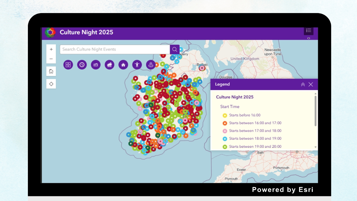
Esri Ireland, the market leader in Geographic Information Systems (GIS), today announces that The Arts Council has used Esri’s technology to create a digital map of events happening around Ireland for Culture Night 2025 – which falls tonight, Friday 19th September.

The interactive, easy-to-use map will chart your cultural course and help you to navigate over 1,800 free events taking place across the island of Ireland. From music, theatre, and comedy to poetry readings, walking tours, and puppet workshops, there is something for all ages and interests on the 2025 programme.

The Arts Council has created a digital map of events happening around Ireland for Culture Night 2025 using Esri’s technology

The Culture Night digital map allows you to search for events by county, location, venue, and event name. It also allows you to search by start time, age suitability, and accessibility.

The event’s 20th edition, Culture Night celebrates the richness and diversity of culture in Ireland today.

Esri Ireland and Murphy Geospatial to accelerate rollout of vital infrastructure projects

Esri Ireland, the market leader in Geographic Information Systems (GIS) has announced a new partnership with surveying and data acquisition specialist, Murphy Geospatial (a Woolpert Company).

This strategic collaboration will combine advanced location intelligence and geospatial data capabilities to accelerate the delivery of large-scale infrastructure, urban planning, and environmental projects across the island of Ireland.

The announcement comes as the Government recently pledged an overall investment of more than €100 billion in Ireland’s infrastructure over the next five years as part of the National Development Plan (NDP).

As vital infrastructure projects grow ever more complex, organisations increasingly require data that is highly accurate and detailed. The demand for real-time mapping capabilities, spatial analytics, 3D modelling, building information modelling (BIM) integration and digital twin representation is rising across sectors such as architecture, engineering, construction, manufacturing, utilities, and energy.

This new partnership will combine Esri’s cutting-edge ArcGIS System with real-time data acquisition and integration services from Murphy Geospatial, driving actionable insights across the entire lifecycle of critical infrastructure projects. Both public and private sector organisations will benefit from powerful digital mapping and precise data capture, enabling faster, more informed decision-making. Streamlined processes and increased automation will transform raw data into interactive maps and valuable analytics, supporting project implementation and enhancing the delivery of essential services.

Esri Ireland and Murphy Geospatial customers will benefit from enhanced data acquisition and analysis capabilities, particularly in field-collected data and on large-scale data projects. Murphy Geospatial deploys aerial, vehicle-mounted, and terrestrial scanners to gather data, ensuring access to even hard-to-reach locations. All data is subjected to rigorous quality control and assurance, reducing the risk of data loss or misinterpretation.

More efficient workflows will drive productivity and collaboration for organisations, while easing the burden on internal teams. Additionally, customers will gain access to increased resources from both Murphy Geospatial and Esri Ireland, supporting project success at every stage.

Paul Synnott, Managing Director of Esri Ireland, commented:
“The Government’s recent funding boost for the NDP marks the largest infrastructure investment in Irish history. Now, more than ever, our customers will rely on high-quality, accurate, and precise data to help them better understand the influence of location, place, and geography on their decisions. Our partnership with the team at Murphy Geospatial enables us to bring their market-leading data acquisition expertise directly to our customers. It’s a partnership that simply makes sense, combining the power of Esri’s ArcGIS system with Murphy Geospatial’s advanced data acquisition solutions to deliver value far greater than the sum of its parts.”

Niall Murphy, CEO of Murphy Geospatial, added:
“Data accuracy demands are rising, and customers need confidence in their data in order to drive today’s increasingly complex projects. Data and GIS systems often live in silos, but this partnership will combine these advanced capabilities to deliver solutions to key industry challenges. From building bridges and developing transport lines to implementing flood relief measures, the potential of geospatial data is huge, and we look forward to leveraging location intelligence to drive further actionable insights. This partnership will accelerate project successes, add increased value, and fuel growth for both customer bases.”

Esri Ireland accelerates national soil survey across 23,000km2 for Aurum Exploration

Esri Ireland, the market leader in Geographic Information Systems (GIS), today announces that its digital mapping system enabled Aurum Exploration Services to accelerate the survey of soil samples across almost 23,000km2 in Ireland.

The extensive survey was carried out as part of the Tellus Programme. Led by Geological Survey Ireland and funded by the Department of the Environment, Climate and Communications, the Tellus Programme aims to improve the future management of the environment by building a deeper knowledge of Ireland’s soil, rocks, and water.

Esri’s ArcGIS technology streamlined workflows for Aurum Exploration, enabling it to deliver the ambitious project in just over one year. The technology replaced the traditional paper-based survey process with innovative digital data capture. The paper-based process was time-consuming with a complex data collection method, taking the Tellus Programme team nine years to reach the halfway milestone on the project.

Using the technology, Aurum Exploration’s sampling teams were able to collect, record, and share real-time data on soil samples – ranging from location to land usage and soil characteristics – wherever they were working in the field. Apps could be used even when offline, which was vital for those working in remote locations. Team leaders were able to speedily assign tasks, manage daily workloads, and monitor the project’s progress, while programme managers could oversee the data collection process and share project metrics.

Health and safety were boosted for employees as each team’s location was visible in near real-time. The platform also facilitated rigorous quality control checks, greatly enhancing the accuracy and integrity of soil sample data. Moreover, reports could be generated on-demand, saving time for teams internally.

In turn, these efficiencies contributed to an estimated saving of 120 days per year, and a reduction in overall operational costs of around €40,000 annually for the project.

Judith Mather, Project Manager, Tellus Programme, Aurum Exploration said: “Having a robust and efficient digital system greatly assisted us to cover more ground in a shorter time, and oversight of the national programme really improved. ArcGIS Dashboards gave our directors and client an accurate and visual real-time overview of what was going on, on a national scale, which is what they needed. In addition, the improvement in data quality was a real testament to the success of ArcGIS applications.”

Schalk van Lill, Customer Success Manager, Esri Ireland said: “Our ArcGIS platform has been transformative for the Tellus Programme, and we were delighted to work closely with Aurum Exploration as the team delivered on this vital nationwide project. Reliable data was captured electronically out in the field, reducing the risk of human error and other data collection inconsistencies, even while working remotely. This also boosted productivity, streamlined operations, and improved collaboration among teams for Aurum Exploration. This important project is benefitting our environment now and into the future.”

Sport Ireland digitally maps over 12,000 recreational facilities in Ireland

Esri Ireland, the market leader in Geographic Information Systems (GIS), today announces that its digital mapping system is being used by Sport Ireland to digitally map over 12,000 recreational locations and facilities across the island of Ireland.

Sport Ireland has launched Get Ireland Active, a national digital hub which maps sports and recreation facilities, walking and cycling trails, public parks, and other amenities around the country to promote higher levels of physical activity.

Sport Ireland is the national authority responsible for developing sport and outdoor recreation in Ireland. Based on Esri’s ArcGIS system, Sport Ireland and Derilinx created Get Ireland Active, which anticipates over 15,000 visitors per month and aims to inspire people to get involved in sport and other recreational activities to improve their health and wellbeing.

The interactive digital map addresses the need for a single, authoritative source of data about sports facilities in Ireland that can provide ways for citizens to become more active, and can also be used to support policy decisions and inform the development of new facilities.

Validated data, for the whole of Ireland, is available to stakeholders via the fully interactive online data hub, created with ArcGIS Hub Premium. Users can collate, verify, analyse, and share data in real-time, including development, planning, and socio-demographic information. This provides actionable insights and allows policy makers in central and local government, sporting bodies, and other stakeholders to analyse gaps in the provision of services and easily identify development land or other potential areas that might be available to site new facilities.

Sport Ireland conducted audits of all sports facilities in Ireland to create the central data hub, which is flexible and scalable and will continue to be updated as data is made available.

Dr Úna May, CEO, Sport Ireland, said: Esri Ireland’s expertise has been crucial in bringing the Get Ireland Active database to life. Their technology allows us to offer a user-friendly platform that has comprehensive information about recreational activities across Ireland.

“Technology is transforming how we approach our everyday lives, and it’s vital that we use this to our benefit. Our collaboration with Esri Ireland has made this a reality, and we are excited to build upon this work through the continued development of the Get Ireland Active database.” 

Padraig Quinn, Senior Account Manager, Esri Ireland, said: “We are proud to have supported the development of the Get Ireland Active national database, Ireland’s interactive activity, sport, and recreation hub. The benefits of having an interactive hub which can direct members of the public to their closest sport or recreation facilities are invaluable, especially coming into the winter months. Furthermore, the hub will continue to inform future development of sporting facilities across Ireland and embed a love of sport and the outdoors for both present and future generations. We are looking forward to continuing to work with Sport Ireland as the hub continues to grow.”

Esri maps over 200 spooktacular events around Ireland this Halloween

Esri Ireland, the market leader in Geographic Information Systems (GIS), has created a digital map of over 200 frightfully fun festivals and events happening across the island of Ireland this Halloween.

Esri’s ArcGIS digital mapping system was used to create an interactive map which features something for everyone this spooky season. The map details daytime and family-friendly events, as well as events for those who fancy more of a scare.

From creepy campfire tales in Belfast and after-dark jail tours in Cork, to a nightmare on Church Street in Mayo and a ghostly bus tour in Dublin, this map will help ghosts and ghouls of all ages and interests plan their celebrations for Halloween 2024.

Esri Ireland strengthens utility sector expertise with UDC partnership

Esri Ireland, the market leader in geographic information system (GIS) technology in Ireland, has teamed up with the digital utility services provider UDC to offer specialist consulting services for Esri Ireland’s utility sector. Through this partnership, gas, electricity, water and wastewater companies will be able to access enhanced support when implementing ArcGIS Utility Network, Esri’s next generation spatial information system for utility management.

“Several of Esri Ireland’s customers in the utility sector are planning to migrate to ArcGIS Utility Network or have already begun on this journey,” says Paul Synnott, Managing Director of Esri Ireland. “By collaborating with UDC, we are giving our customers easy access to utility sector specialists who can advise them about data migration and help them optimise the benefits they gain from their investment in Esri technology.”

Where appropriate, consultants from UDC will join Esri Ireland projects and work alongside Esri Ireland’s Professional Services Team to deliver agreed outcomes for utility customers. In particular, UDC will provide guidance on best practice data cleansing and data migration methods and advise customers on how to represent utility assets digitally. Utilities will also be able to take advantage of UDC’s proprietary auto-migration HEIDE tool, which helps accelerate data migration processes.

Esri Ireland and UDC have already worked together on a successful collaboration with Northern Ireland Electricity (NIE) Networks. As part of a project team led by Esri Ireland, UDC carried out a Data Readiness Assessment to evaluate the utility’s data quality, highlighted data recommendations and prepared it for a full data migration. This allowed NIE Networks to quantify the time and resources it will need to migrate data to the new system.

UDC has been providing ArcGIS-based solutions and services for utilities in the USA and Canada for nearly twenty years. It is a Platinum Partner in the Esri Partner Network programme and holds Esri specialty certifications in gas and electric utilities services. For organisations that are migrating to ArcGIS Utility Network, it delivers services ranging from strategic roadmap guidance to data assessment and migration readiness planning, and full migration support.

“After successfully serving North American utilities for the last 20 years, we now have had the good fortune to cross the Atlantic, forge a strong and growing partnership with Esri Ireland, and work with utilities in Ireland,” shares Hamid Akhavan, CEO of UDC. “We are delighted to be working with the fantastic Esri Ireland team, helping more gas, electric and water utilities achieve maximum benefit through digital transformation, leveraging ArcGIS Utility Network.”