Garmin introduces inReach Mini 3 Plus satellite communicator

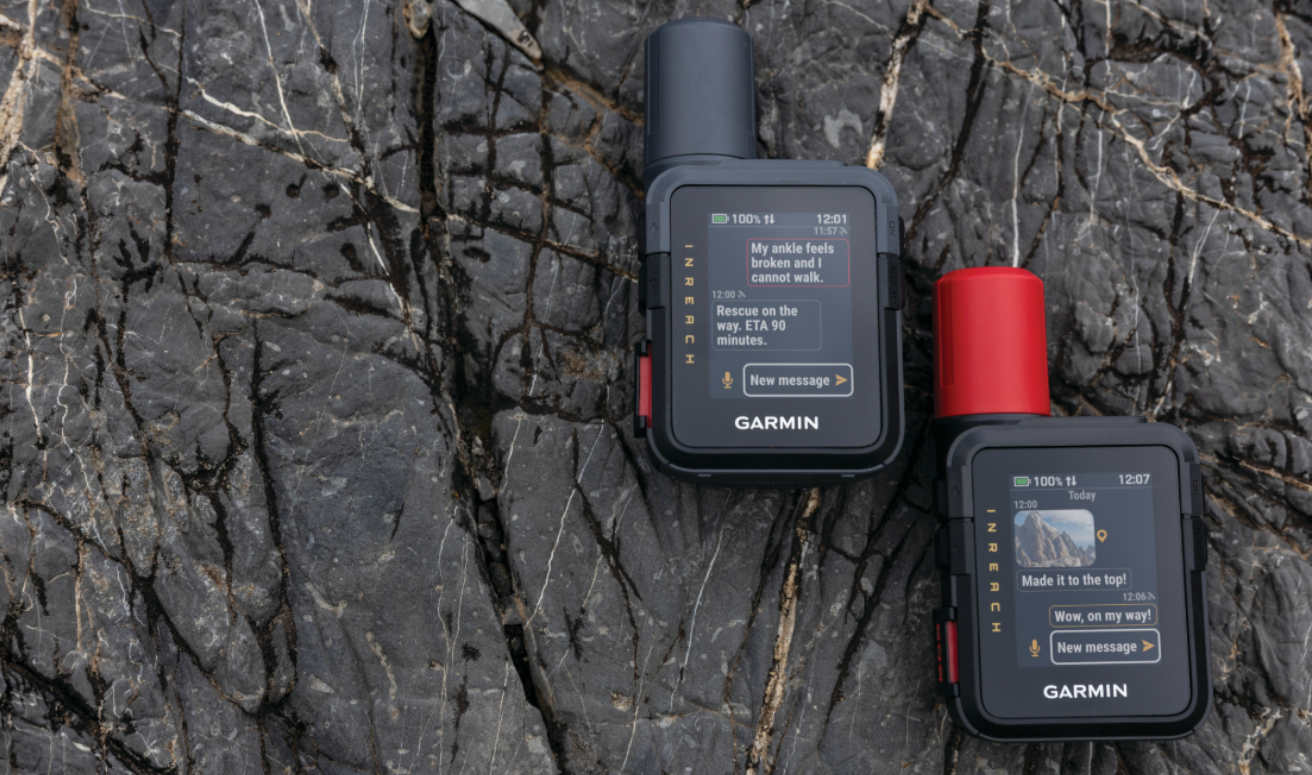
Garmin is expanding its popular lineup of compact satellite communicators with the introduction of inReach® Mini 3 PlusFeaturing a colour touchscreen display and built-in speaker and microphone, inReach Mini 3 Plus lets adventurers exchange voice messages, texts and photos1—making it easier to stay in touch with family and friends who are back home. Purpose-built to provide extra peace of mind while exploring beyond cell coverage, users can also trigger an interactive SOS message to the Garmin Response℠ centre should an emergency occur. And with up to 330 hours of battery life in 10-minute tracking mode, inReach Mini 3 Plus can be used on multi-day trips without the need for any extra plug-ins or battery chargers.

 “We understand just how important it is to stay connected during both short and long adventures, and that’s why we are excited to bring even more communication tools to the inReach Mini 3 Plus. Tell friends and family that they’re missed, show them the amazing view while standing at the summit and more—all from this compact and rugged device that can be clipped to a pack.”

—Susan Lyman, Garmin Vice President of Consumer Sales and Marketing

 More ways to stay in touch


  • Voice messaging: Check in with family and friends by exchanging 30-second voice messages right from the device.
  • Voice message transcription: While in an area where listening isn’t possible or it’s necessary to maintain silence in the field, read transcriptions of voice messages directly on the device.
  • Touchscreen texting: Quickly exchange text messages (up to 1,600 characters), emojis and reactions or start a group chat right from the device.
  • Photo sharing: View photos from back home right on the colourful display and share photos from every epic adventure when using the Garmin Messenger app.
  • LiveTrack location sharing: Let friends and family follow along on the adventure and track progress, including distance, time and elevation1.

 Emergency support when it’s needed the most

 When an SOS message is triggered, inReach Mini 3 Plus will send an interactive message to the Garmin Response centre, where a dedicated team of skilled emergency response coordinators are ready at any time. Photo and voice messages can also be shared during an SOS, giving coordinators the ability to see and hear details of the emergency firsthand. Response coordinators will communicate with the user, their listed emergency contacts, search and rescue organisations and other available local resources and provide updates. With nearly two decades of experience, the Garmin Response team has supported more than 18,000 inReach incident responses – from land to sea to air – in more than 150 countries on all seven continents.

Built for any adventure, inReach Mini 3 Plus is made to operate in extreme temperatures and features an impact-resistant design and IP67 water rating. When paired with the Garmin Explore app, adventurers can plan a trip, follow a course to a destination and even follow a track back to the start.

inReach Mini 3 Plus is available now and has a suggested retail price of £439.99. To learn more, visit www.garmin.com.

Engineered on the inside for life on the outside, Garmin products have revolutionised life for adventurers, athletes, off-road explorers, road warriors and outdoor enthusiasts everywhere. Committed to developing products that enhance experiences, enrich lives and help provide peace of mind, Garmin believes every day is an opportunity to innovate and a chance to beat yesterday.

1 Active satellite plan required. Some jurisdictions regulate or prohibit the use of satellite communication devices. It is the responsibility of the user to know and follow all applicable laws in the jurisdictions where the device is intended to be used.

See our Garmin Reviews

Google Pixel Watch 4 45mm Smartwatch Review

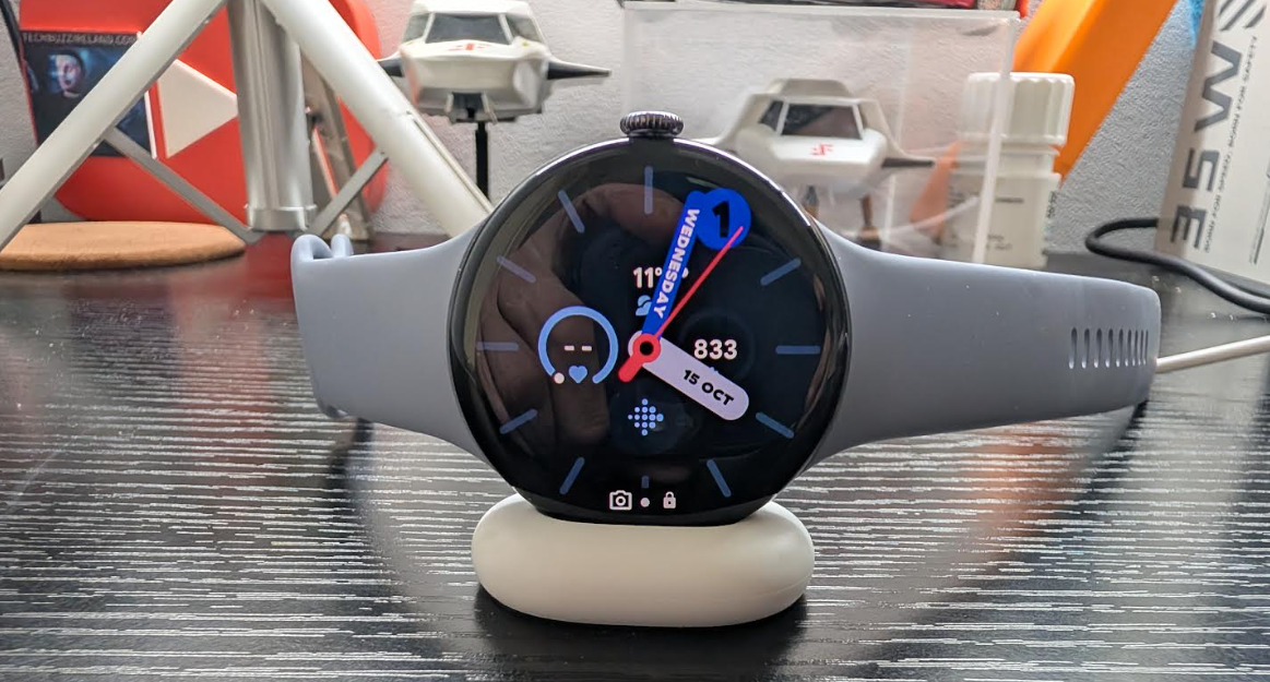
The Google Pixel Watch 4 is arguably the most significant update yet in the Pixel wearable line and coming from the Pixel Watch 3 45 mm I was looking forward to testing this one out and seeing how much it has improved there is some sublte differences and to look at both head on you might find it hard to notice..

The most noticeable improvement is the Actua 360 display, which is now 10% larger with noticeably slimmer bezels and a dazzling 3,000 nits of peak brightness, making it easy to read even in direct sunlight. Performance is snappy thanks to the new Snapdragon W5 Gen 2 chip, but the real software star is the deeply integrated Gemini AI, which can be instantly activated with a simple “Raise to Talk” wrist gesture—a genuine game-changer for on-the-go queries and commands. IN short the watch can replace your phone with Gemini AI for anyhting and with that said the watch for me keeps me off my phone and now it helps even more which is a good thing in my book but I still love my Pixel 10 pro.

Crucially, the Watch 4 substantially boosts battery life (up to 40 hours on the 45mm model) and introduces super-fast charging, hitting 50% battery in just 15 minutes via a redesigned, convenient side-charging dock. For the health-conscious, dual-frequency GPS provides exceptional outdoor tracking accuracy. For me I would get a day and a half due to how much I have going to the watch but the fast charging helps and I do not wear a watch to bed however for those that do you will notice the faster charging and the new doc is excellent and welcome.

The Pixel Watch 4 also has fitness in mind with Fitbit inlcuded at a cost after your sub runs out and is now integrated into the Watch app I do take note of my fitness but no a fully fledged fitness freak but there is more than enough here for the fitness and health gurus especially with all the safety and medical alerts now on board.

The Pixel Watch app itself is simple to use and works well letting you customize to your requirements and it is a simple UI to use and navigate making it a comfortable experience all round you can see the screenshots below for exactly what you get and also in the video review.

Overall I am a fan of the watch as I was last years and the display really stands out,notifcations are clear and so are calls and the speaker is also better this time round letting you hear what is being said or for taking calls it is at the higher end with the price point but if like me and have a Google Ecosystem it all just works well and is seamless and if you have and Google cameras at home it is even better and notifications are rich and as you would find on your Pixel phone.

Pixel Watch App


FitBit 


Features

  • Innovative design all the way around. A leap forward in precision craftsmanship, with a first-of-its-kind Actua 360 domed display and powerful health and fitness sensors.
  • Iconic Actua 360 display. See it all and do the most with a 10% larger Active display that’s 50% brighter and as durable as ever with scratch-resistant Gorilla Glass.
  • The best watch for Gemini. Just ask questions and your ultra capable AI assistant will deliver quick response for personalised help.
  • Longest lasting. Fastest charging. With 25% faster charging and Google’s longest battery life yet, the Pixel Watch 4 is ready when you are.
  • AI text suggestions that sound like you. Stay connected with AI-powered quick replies when you’re texting – they’re personalised with your style and hyper-relevant to your conversation.
  • A leading approach to better health. The Pixel Watch 4 helps you to understand your health with Google’s most accurate heart rate tracking, sleep insights, Health Metrics and more.
  • Training smarter starts with the Pixel Watch 4. It connects the dots between your activity and recovery, so you can make informed decisions about your workouts and optimise your performance.
  • Detects loss of pulse, then calls for help. Loss of Pulse Detection can detect a loss of pulse event and prompt a call to emergency services for potentially lifesaving help.
  • SOS satellite communications. Get help even if you’re in a remote location – the Pixel Watch 4 can connect you to emergency services through geo-stationary satellites.
  • Get help if you need it. If you’re in a situation where you feel unsafe, the Pixel Watch 4 can alert trusted contacts or 999 with Emergency SOS.

BUY

Other Google Reviews

Video Review

Garmin launches first microLED watch and brings inReach to your wrist

Garmin  is advancing the future of smartwatch technology with the introduction of fēnix® 8 Pro series. These premium GPS smartwatches are the first to feature inReach technology for satellite and cellular connectivity—letting athletes and adventurers leave their phone behind and still stay in touch. Further revolutionising the smartwatch industry, fēnix 8 Pro – MicroLED introduces a first-of-its-kind, high-resolution MicroLED display for superior readability.

“fēnix 8 Pro is changing the game for smartwatches. This new lineup is full of breakthrough innovations, bringing life-changing inReach technology to the wrist to help keep athletes and adventurers in touch with their family and friends and introducing the first-ever ultra-bright MicroLED display to a smartwatch so users can see their maps, stats, health and wellness metrics and more like never before.”

—Susan Lyman, Garmin Vice President of Consumer Sales and Marketing

Leave the phone behind and still stay connected

Designed for those pursuits that make it impractical to carry a phone, fēnix 8 Pro has built-in inReach technology for satellite and cellular connectivity.

Satellite connectivity

fēnix 8 Pro uses inReach technology to let explorers exchange messages and send location check-ins.

  • Text messages: Send and receive text messages with those using the Garmin Messenger app on their smartphone or compatible Garmin smartwatch.
  • Location check-ins: Send location updates to family and friends so they can keep track of trip progress.

Cellular connectivity

In addition to sending text messages or providing location check-ins, fēnix 8 Pro can be used to make phone calls, send voice messages, share LiveTrack links and view weather forecasts when connected to the LTE network.

  • Voice calls: Make and take voice calls from the watch with other fēnix 8 Pro users or those using the Garmin Messenger app on their smartphone.
  • Voice messages: Check in with family and friends by exchanging 30-second voice messages. Recipients can listen to the messages or read the transcriptions on their watch or in the Garmin Messenger app.
  • LiveTrack: Friends and family can follow the adventures with LiveTrack location sharing and location check-ins on their smartphone. Users can also alert their friends and family when a LiveTrack session has started, in case they want to follow along or reach out during an activity.
  • Weather forecasts: Access current weather conditions and multiday forecasts to stay prepared for what’s ahead.

SOS capability supported by Garmin Response

When an SOS is triggered, fēnix 8 Pro will send a message over satellite or cellular connectivity to the Garmin Response center, where a dedicated team of skilled emergency response coordinators are ready at any time. From there, Garmin Response will communicate with the user, their listed emergency contacts, search and rescue organisations and other available local resources. They provide updates to users and emergency contacts on the response effort, including confirmation when help is on the way, and remain available as the incident is being resolved. With nearly two decades of experience, the Garmin Response team has supported more than 17,000 inReach incident responses in more than 150 countries on all seven continents.

First-of-its-kind MicroLED display

Offering remarkable brightness in exquisite detail, fēnix 8 Pro – MicroLED features over 400,000 individual LEDs delivering up to 4,500 nits, making it the brightest smartwatch ever. The result is a revolutionary display that produces rich colors and high pixel densities with wide viewing angles and superior readability—even in direct sunlight.

Rugged design, premium features

Made for any adventure, all fēnix 8 Pro models are dive-rated and feature leakproof metal buttons, a metal sensor guard cover, AMOLED or MicroLED touchscreen displays and titanium bezels, plus an LED flashlight for greater visibility in dark environments.

Built for wherever the adventure leads, fēnix 8 Pro is loaded with Garmin’s full suite of performance, navigation, health and wellness2, and connected features, including endurance score, hill score, daily suggested workouts, preloaded TopoActive Maps, dynamic round-trip routing, the Garmin ECG App3, sleep coach, Garmin Pay, safety and tracking features and more. To learn more, visit https://www.garmin.com/en-IE/.

AI + Satellite Data: The Tech Solution to America’s Aging Grid Problem

CATALYST is revolutionizing one of Electric Utilities’ biggest operational challenges with the launch of INSIGHTS Vegetation Management, a satellite-based monitoring service that helps reduce outages and enhance reliability by identifying where networks are at greatest risk.

Vegetation is a major cause of power outages and contributes to infrastructure damage and wildfires. As extreme weather events become more frequent, Utilities face increasing challenges in maintaining grid stability. Managing vegetation is costly with major U.S. Utilities spending over $100 million annually. However, this spending can be inefficient – without insights into current vegetation conditions, traditional inspection and pruning programs are forced to revisit areas on fixed cycles rather than prioritizing areas at highest risk. 

A Targeted Approach to Vegetation Risk Management

CATALYST’s INSIGHTS Vegetation Management replaces fixed maintenance schedules with condition-based working informed by regular network-wide intelligence. Its insights enable arborists to optimize operations by focusing inspection and maintenance crews on areas where risk is highest. The solution also provides post-work verification to confirm the effectiveness of completed vegetation management activities. Additionally, it can deliver critical insights into the extent and relative intensity of vegetation damage following extreme weather events.

“INSIGHTS Vegetation Management expands CATALYST’s suite of risk monitoring solutions, equipping Utilities with essential intelligence to improve resilience and operational efficiency,” said June McAlarey, President and CEO of PCI Geomatics, “By leveraging advanced satellite technology, Utilities can actively target vegetation risks, reducing outages and ensuring safer, more reliable service for their customers.”

INSIGHTS combines high-resolution satellite imagery with Utilities’ and environmental data to identify high-risk trees and quantify threats. Unlike black-box AI models, it offers transparent, science-based risk assessments that can be customized to utility needs. 

As a data-as-a-service (DaaS) solution, INSIGHTS integrates with Geographic Information Systems (GIS), Enterprise Resource Planning (ERP) platforms and field management tools, providing Utilities with accessible actionable intelligence. Developed through CATALYST’s extensive experience in Earth observation analytics and advanced library of processing algorithms, INSIGHTS Vegetation Management delivers reliable and precise risk assessments tailored to Utility operations.

INSIGHTS Vegetation Management is now available as the latest addition to CATALYST’s wide-area monitoring capabilities that also include INSIGHTS Ground Displacement Monitoring, change detection, and terrain modelling. 

NSAI Launches Europe’s First Verified Global Navigation Satellite System Data Stream Service

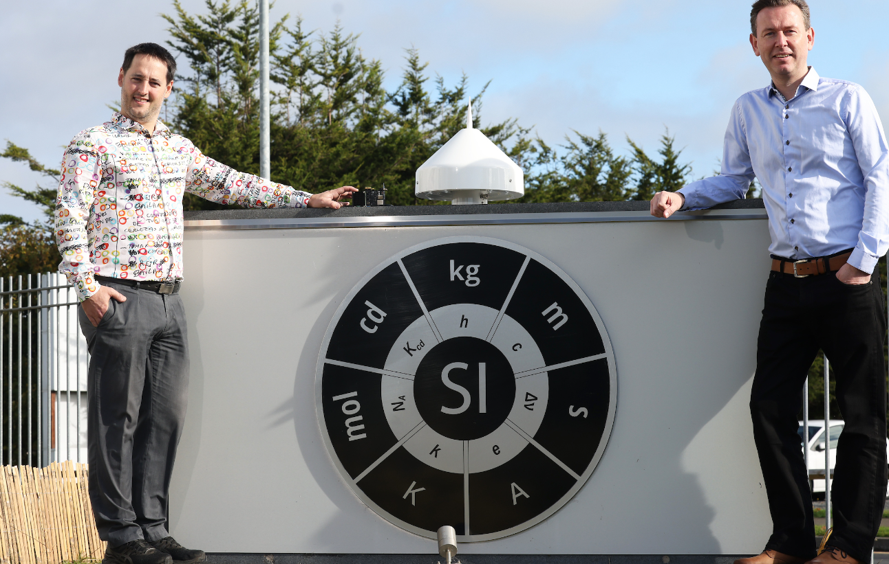
The National Standards Authority of Ireland’s National Metrology Laboratory (NSAI NML) today announced the launch of Europe’s first ever verified GPS/GNSS Data Stream (VGDS) service, an extension to the National Timing Grid of Ireland (www.ntg.ie). This initiative developed in partnership with Timing Solutions, marks a significant step forward in ensuring secure and reliable Global Navigation Satellite System (GNSS) data, vital for government organisations, public institutions and business sectors including communications, energy, and transportation, public services, financial services, and cloud data centers as a source of accurate time.
The VGDS service provides verified GNSS data in the form of Radio Technical Commission for Maritime Services (RTCM) packets via the internet, allowing users to verify their own GNSS data streams.
GNSS (Global Navigation Satellite Systems), such as the US’s Global Positioning System (GPS) and the EU’s Galileo, are invaluable in our daily lives as they provide real-time navigation assistance for people and assets helping them find the most efficient routes, avoid traffic, and reach their destinations safely and quickly. In emergency situations, GNSS devices help locate individuals quickly, allowing first responders to reach them faster.
David Fleming, NSAI Technical Manager for Time & Frequency said,
“We are so excited to be launching in Ireland, Europe’s first ever Verified GNSS/GPS Data Stream service. As Ireland’s digital economy continues to grow and more services and public safety aspects are dependent on GNSS/GPS data, the importance of verifiable GNSS/GPS data in Ireland is paramount which made the establishment of this service a key priority for the NSAI NML.”
As Ireland’s national authority for measurement standards, NSAI NML is responsible for creating, maintaining and developing the national measurement standards for physical quantities (e.g. kilogram, second, meter, etc.) and making these standards available to Irish users. The VGDS service is being delivered by NSAI NML and led by specialist partner Timing Solutions, a NovaUCD and ESA BIC Ireland client company.
Dr. Zdenek Chaloupka, Founder, Timing Solutions said:
“The Timing Solutions team is delighted to be taking the lead in establishing Ireland as one of the leading countries around the world with respect to the provision of safe GNSS/GPS data and signals thereby improving the resiliency of the Critical Infrastructure sectors.”
GNSS systems like GPS have become an essential part of everyday life, from driver navigation and optimising farming operations to coordinating emergency services. However, their widespread use has also exposed vulnerabilities that can be exploited for criminal activities, including signal jamming and spoofing—both of which can disrupt crucial services and threaten public safety.
By offering a verified stream of GNSS data, the VGDS service mitigates these risks, ensuring that users in Ireland and beyond can trust the accuracy and reliability of their location and timing data. This service is particularly critical for Critical Infrastructure sectors, which depend on GNSS for accurate timekeeping, communications, and operational efficiency.
Dr. Chaloupka from Timing Solutions is presenting this new initiative at the International Time and Sync Forum (ITSF 2024), the world’s largest timing and sync event, gathering in Seville in November 2024. Access to the VGDS service can be requested by emailing NSAI NML at gnssdatatrial@nsai.ie or Timing Solutions at vgds@timingsolutions.ie.

How does NTN work? Discussing the best features of Satellite communication

Communication networks are very important in today’s world because they connect people, companies, and governments worldwide. Non-Terrestrial Networks (NTN) are one sophisticated system that has attracted much interest lately. NTN is pushing how we remain connected as satellite communication develops, especially in places conventional networks cannot reach. Emphasizing NTN’s importance in satellite communication, this paper will examine how it operates and its finest characteristics.

What is NTN?

Non-Terrestrial Networks (NTN) is a communication method wherein areas without typical terrestrial networks (such as fiber optics or cell towers) may have internet and network services using satellites, drones, or other aerial platforms. From rural places to even mobile situations like ships and aircraft, NTN provides a way to link far-off or difficult-to-reach locations.

While terrestrial networks run in space or the air, NTN guarantees a wider and more flexible reach, while ground-based infrastructure such as towers and cables forms the foundation of both. This makes military operations, emergency communications, and increasing internet access to underprivileged regions very vital.

How Does NTN Work?

NTN establishes communication linkages mostly via satellites circling the Earth. This is a detailed walk-through of this system’s operation:

  • Communication of Signals


In an NTN system, satellites pick up data signals from a base station—an Earth station. These signals might include video streams, audio chats, or internet data.

  • Satellite Relay

After receiving the signals, the satellite forwards them either straight to a ground-based receiver, such as a remote station, mobile device, or aircraft, or another satellite.

  • Ground Communication

These messages are sent back to Earth by the satellite. Ground stations or individual users can then receive the data, such as a phone call, an internet link, or information about guidance.

Best NTN Features for Satellite Communication

NTN is a necessary instrument for satellite communication as it presents various benefits and characteristics and has become more important in worldwide communication networks. Let’s investigate some characteristics:

Reliability and Fortitude

NTN is quite strong. Unlike terrestrial networks, which could be damaged by physical damage to towers or cables, NTN’s satellite-based infrastructure is resistant to many problems afflicting ground networks. Although natural events such as floods, earthquakes, or wildfires could compromise terrestrial communication networks, NTN operates in these circumstances and provides vital communication for emergency services and rescue.

This robustness makes NTN an excellent option for humanitarian missions, disaster recovery operations, and any situation where preserving communication is vital.

Enhanced Rural Area Connectivity

Building terrestrial infrastructure like fiber-optic cables is costly and time-consuming, so rural and remote locations can lack high-speed internet and other communication services. By beaming down satellite internet services, NTN closes the connection disparity for rural areas.

For those living in these places, this enhanced connection helps to provide greater access to healthcare, education, and economic possibilities. While telemedicine services enable healthcare practitioners to access patients in remote areas, high-speed internet may aid rural schools in providing online learning tools.

Backing for Mobility

One of NTN’s most vital points is its capacity to provide consumers with on-the-go connections. NTN ensures that lines of contact stay available, whether in distant military operations, aboard ships, or aircraft. For example, aircraft passengers may use NTN satellite systems to access the internet when traveling over the ocean or far-off areas.

Similarly, ships in the middle of the ocean may keep in touch with land utilizing satellite-based data and instruction receipts. For sectors such as aviation, marine transportation, and military, NTN is very essential because of its mobility.

Reasonably Affordable Growth

Expanding terrestrial networks to serve sparsely inhabited or far-off locations may be expensive. Laying cables, erecting towers, and preserving infrastructure needed for large financial outlay. By providing a reasonably priced substitute, NTN enables companies to deliver internet and communication services without requiring significant ground infrastructure.

For nations or areas with few resources to create conventional networks yet need high-quality communication services, NTN is thus a perfect choice. NTN may often be implemented as less expensive and quicker than terrestrial alternatives.

Compatibility with 5G

NTN is positioned to complement and improve 5G services as 5G networks are being rolled out. Through integration with terrestrial 5G networks, NTN can access regions beyond the reach of conventional 5G towers. Faster, more dependable internet services in regions where 5G alone may find it challenging to deliver coverage would be made possible by this alliance between NTN and 5G.

NTN can assist, for instance, distant industrial activities, 5G services for rural areas, or even highway travelers far from cities. This flawless integration guarantees that more individuals might benefit from 5G technology’s speed and efficiency.

Conclusion

Particularly in locations beyond the scope of conventional terrestrial networks, NTN is transforming our communication, Modern communication systems must include it because of its capacity to provide worldwide coverage, durability against natural catastrophes, and support of mobile settings. NTN will become more and more vital as satellite communication technology develops to link the globe and provide a dependable, adaptable, reasonably priced service for both urban and rural areas.