Dublin Fire Brigade invests in location intelligence

Esri Ireland, the market leader in Geographic Information Systems (GIS), announces that Dublin Fire Brigade has deployed a new digital mapping system designed to improve emergency response, strengthen firefighter and public safety, and enhance how critical resources are allocated across Dublin city and county.

Ireland’s largest fire and rescue service, Dublin Fire Brigade was founded over 160 years ago. It provides fire, rescue, and emergency ambulance services 24 hours a day, 365 days a year, to Dublin’s 1.5 million citizens. It recently established a new Organisational Intelligence Unit with a key goal to optimise the use of location-based information to effectively manage fire risks and help keep communities safe.

Built using Esri’s ArcGIS technology, the new digital mapping system brings together operational data, such as the locations of fire stations and historic fire incidents, with third-party data – including census and population health information – for the first time.

Enhanced insights support increased safety for both the public and firefighters by raising awareness of buildings in Dublin with fire safety issues – such as inadequate means of escape, building defects, or over-occupancy. Using the technology, Dublin Fire Brigade can now map this information and put effective response plans in place that take known issues into account.

What’s more, the technology is enabling Dublin Fire Brigade to carry out more targeted community fire prevention activities by focusing citizen safety campaigns on specific vulnerable groups, especially in locations that are experiencing clusters of dwelling fires. It can easily see where fire safety efforts are still needed to reach at-risk communities, as well as contextual data such as concentrations of smokers or elderly people.

In addition, Dublin Fire Brigade is using Esri’s ArcGIS technology to identify optimal locations for new fire stations as Dublin continues to expand, as well as to ensure that aerial fire appliances are strategically located to reach the tallest and highest-risk buildings.

Dublin Fire Brigade plans to make the system widely available across varying departments within the organisation to enable more strategic planning and informed decision-making.

Rob Howell, Station Officer, Organisational Intelligence Unit, Dublin Fire Brigade, said: “It has been a really successful collaboration. The consultants at Esri Ireland have a high level of expertise, both in terms of their GIS knowledge and their project management skills. This technology gives us the ability to target our fire prevention strategies – we can deliver campaigns in the right locations to reach the most vulnerable people and have the biggest impact in terms of community fire prevention. Equally, we have to consider firefighters’ health and safety as well as that of the general public and, by being better informed, we can improve our responses to incidents and keep our responders safe in fires and other emergency situations. The potential for location intelligence in the fire service is absolutely huge and has a big role to play in our future.”

Gareth McBride, Customer Success Manager, Esri Ireland, said: “Dublin Fire Brigade is continuously evolving the fire service to meet the needs of Dublin’s residents, businesses, institutions, and visitors. To support this, it is embedding geospatial data intelligence at the heart of operational and strategic decision-making. Location intelligence is helping the fire brigade in managing and reducing fire risks, addressing some of the biggest dangers in a changing cityscape. We are delighted to be working with Dublin Fire Brigade on such an important and necessary project, and excited to see its expanded capabilities as the technology is rolled out more widely.”

Esri launches interactive map of festive events in Ireland

Esri Ireland, the market leader in Geographic Information Systems (GIS), has announced the launch of a digital map of fun-filled events happening around Ireland this festive season.

The interactive, easy-to-use StoryMap will help yuletide revellers to navigate what’s on across the island of Ireland this Christmas. From markets and festivals to light shows and ice-skating, there is something to suit all ages and interests.

The festive map includes a Web App enabling the public to search for events by county and location, to make planning your festive adventures even easier.

Esri Ireland specialises in the application of geographic information systems, helping customers record where things happen and analyse why, with the aim of providing insight and helping them to make better decisions.

As Esri’s official point of presence in Ireland and Northern Ireland it has, since 2002, partnered with both the public and private sector to help them understand the impact of geography on their business.

Recognised as one of the Best Workplaces in Ireland, Esri Ireland is part of the Esri Global Network, a billion-dollar privately held software company with nearly 10,000 employees worldwide. www.esri-ireland.ie

Galway County Council’s StoryMaps Wins eGovernment Award

Galway County Council’s innovative StoryMaps project, which has digitised the heritage of communities across County Galway into interactive online experiences, has been named a category winner at the 2025 Ireland eGovernment Awards.

The project received the Open Data Award, having been shortlisted alongside the National Cancer Registry of Ireland.

Galway County Council’s Heritage and GIS sections, working in conjunction with community groups and academia, have so far created over 40 town and village StoryMaps showcasing the rich heritage of the County’s towns, villages, and townlands.

In addition, historical information relating to 1,000 townlands has been digitised, providing a valuable resource for communities, schools, heritage groups, Tidy Towns committees, academia, and the public.

By integrating mapping technology with text, images, and multimedia content, StoryMaps delivers location-based stories that can be accessed on any internet-enabled device, from desktop computers to tablets and phones.

Cllr David Collins, Cathaoirleach of Galway County, said, “This project showcases and promotes knowledge of, and pride in, the rich heritage of our townlands, villages, towns, and other aspects of our heritage. It presents this heritage to local, national, and international audiences and serves as an extremely valuable resource.”

Liam Conneally, Chief Executive of Galway County Council, added, “This project is a fantastic example of how local history can be preserved and shared using modern technology and innovative research techniques. The partnership approach to developing StoryMaps shows how collaboration is central to preserving and sharing our local history.”

Liam Hanrahan, Director of Services for Planning and Economic Development, said the project places a strong emphasis on community engagement, presenting local heritage in a way that is easily accessible to the public, the Irish diaspora, and scholars at home and abroad.

Led by Galway County Council’s Heritage Office and GIS Department, the project was developed in collaboration with the Galway County Community Archaeology Project, University of Galway, Atlantic Technology University (ATU) Galway, ICAN (Irish Community Archive Network) Galway, Galway County Heritage Forum, The Heritage Council, and local Tidy Towns, heritage and community groups.

Bridin Feeney, GIS Analyst in Galway County Council’s ICT Department, said the project is about unearthing stories, local lore, and forgotten histories and presenting them in an engaging digital format.

Outlining the background to the project, she added, “Several community groups approached us wanting to develop a digital platform to showcase the heritage and history of their local areas but lacked the capacity or resources to do so. Working with these groups, our GIS team and Heritage Officer developed a framework to create StoryMaps for their heritage trails and townland research. Some communities had the knowledge but not the digital expertise, so we worked with them and trained them on the possibilities of StoryMaps and how they could reach their target audiences.”

Heritage Officer Marie Mannion said the primary goal of StoryMaps is to make heritage accessible to everyone.

“We initially expected to train local communities and students on how to create StoryMaps and make this information available as open-source data. It has turned out to be much more than that,” she explained. “It has given people confidence in their skills and fostered a strong sense of pride in their communities. The StoryMaps are used by local residents, schools, academics, the diaspora, and many others. They have a myriad of uses, and we are only now discovering additional applications, including their use in ATU Galway’s Heritage Studies course.”

The Ireland eGovernment Awards celebrate excellence, innovation, and creativity in Ireland’s public sector and are recognised as the benchmark for digital government services. This year’s awards were presented by An Taoiseach Micheál Martin TD at O’Reilly Hall, UCD.

Giles Newsome, CEO of iConnect101 and a member of this year’s judging panel, said, “This submission proved very much the value of using GIS, open-source mapping data to deliver something very valuable from Galway County Council to the people of Galway and beyond. What has been done here is the creation and curation of very valuable content on interactive maps about places of interest, historic monuments, historic sites right across County Galway. A fantastic smart use of mapping technology.”

The StoryMaps project is available at www.tinyurl.com/StoryMapGalway.

Digital map charts 1,800 Culture Night events across Ireland

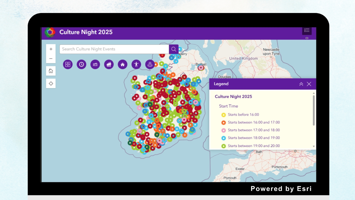
Esri Ireland, the market leader in Geographic Information Systems (GIS), today announces that The Arts Council has used Esri’s technology to create a digital map of events happening around Ireland for Culture Night 2025 – which falls tonight, Friday 19th September.

The interactive, easy-to-use map will chart your cultural course and help you to navigate over 1,800 free events taking place across the island of Ireland. From music, theatre, and comedy to poetry readings, walking tours, and puppet workshops, there is something for all ages and interests on the 2025 programme.

The Arts Council has created a digital map of events happening around Ireland for Culture Night 2025 using Esri’s technology

The Culture Night digital map allows you to search for events by county, location, venue, and event name. It also allows you to search by start time, age suitability, and accessibility.

The event’s 20th edition, Culture Night celebrates the richness and diversity of culture in Ireland today.

Esri Ireland accelerates national soil survey across 23,000km2 for Aurum Exploration

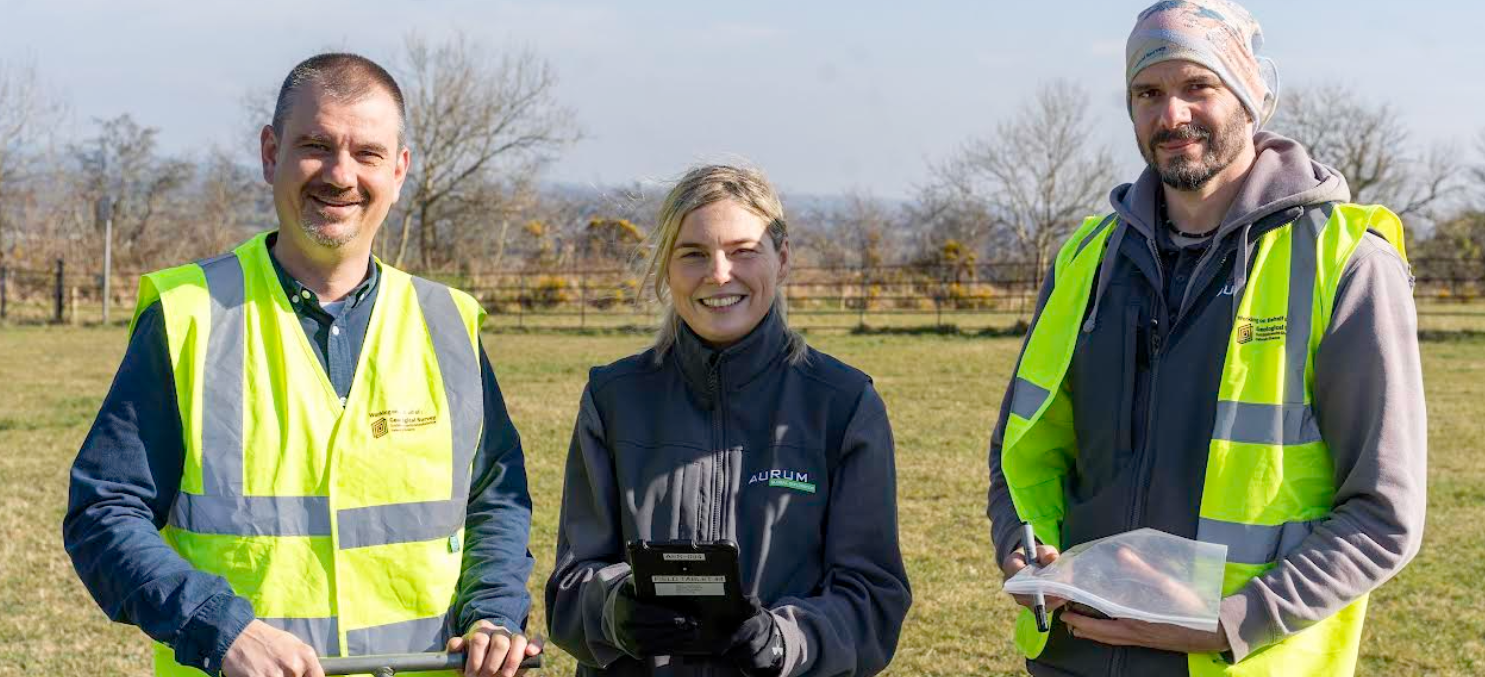
Esri Ireland, the market leader in Geographic Information Systems (GIS), today announces that its digital mapping system enabled Aurum Exploration Services to accelerate the survey of soil samples across almost 23,000km2 in Ireland.

The extensive survey was carried out as part of the Tellus Programme. Led by Geological Survey Ireland and funded by the Department of the Environment, Climate and Communications, the Tellus Programme aims to improve the future management of the environment by building a deeper knowledge of Ireland’s soil, rocks, and water.

Esri’s ArcGIS technology streamlined workflows for Aurum Exploration, enabling it to deliver the ambitious project in just over one year. The technology replaced the traditional paper-based survey process with innovative digital data capture. The paper-based process was time-consuming with a complex data collection method, taking the Tellus Programme team nine years to reach the halfway milestone on the project.

Using the technology, Aurum Exploration’s sampling teams were able to collect, record, and share real-time data on soil samples – ranging from location to land usage and soil characteristics – wherever they were working in the field. Apps could be used even when offline, which was vital for those working in remote locations. Team leaders were able to speedily assign tasks, manage daily workloads, and monitor the project’s progress, while programme managers could oversee the data collection process and share project metrics.

Health and safety were boosted for employees as each team’s location was visible in near real-time. The platform also facilitated rigorous quality control checks, greatly enhancing the accuracy and integrity of soil sample data. Moreover, reports could be generated on-demand, saving time for teams internally.

In turn, these efficiencies contributed to an estimated saving of 120 days per year, and a reduction in overall operational costs of around €40,000 annually for the project.

Judith Mather, Project Manager, Tellus Programme, Aurum Exploration said: “Having a robust and efficient digital system greatly assisted us to cover more ground in a shorter time, and oversight of the national programme really improved. ArcGIS Dashboards gave our directors and client an accurate and visual real-time overview of what was going on, on a national scale, which is what they needed. In addition, the improvement in data quality was a real testament to the success of ArcGIS applications.”

Schalk van Lill, Customer Success Manager, Esri Ireland said: “Our ArcGIS platform has been transformative for the Tellus Programme, and we were delighted to work closely with Aurum Exploration as the team delivered on this vital nationwide project. Reliable data was captured electronically out in the field, reducing the risk of human error and other data collection inconsistencies, even while working remotely. This also boosted productivity, streamlined operations, and improved collaboration among teams for Aurum Exploration. This important project is benefitting our environment now and into the future.”

AI + Satellite Data: The Tech Solution to America’s Aging Grid Problem

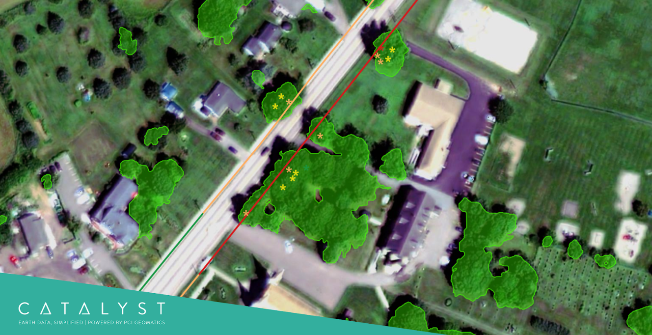
CATALYST is revolutionizing one of Electric Utilities’ biggest operational challenges with the launch of INSIGHTS Vegetation Management, a satellite-based monitoring service that helps reduce outages and enhance reliability by identifying where networks are at greatest risk.

Vegetation is a major cause of power outages and contributes to infrastructure damage and wildfires. As extreme weather events become more frequent, Utilities face increasing challenges in maintaining grid stability. Managing vegetation is costly with major U.S. Utilities spending over $100 million annually. However, this spending can be inefficient – without insights into current vegetation conditions, traditional inspection and pruning programs are forced to revisit areas on fixed cycles rather than prioritizing areas at highest risk. 

A Targeted Approach to Vegetation Risk Management

CATALYST’s INSIGHTS Vegetation Management replaces fixed maintenance schedules with condition-based working informed by regular network-wide intelligence. Its insights enable arborists to optimize operations by focusing inspection and maintenance crews on areas where risk is highest. The solution also provides post-work verification to confirm the effectiveness of completed vegetation management activities. Additionally, it can deliver critical insights into the extent and relative intensity of vegetation damage following extreme weather events.

“INSIGHTS Vegetation Management expands CATALYST’s suite of risk monitoring solutions, equipping Utilities with essential intelligence to improve resilience and operational efficiency,” said June McAlarey, President and CEO of PCI Geomatics, “By leveraging advanced satellite technology, Utilities can actively target vegetation risks, reducing outages and ensuring safer, more reliable service for their customers.”

INSIGHTS combines high-resolution satellite imagery with Utilities’ and environmental data to identify high-risk trees and quantify threats. Unlike black-box AI models, it offers transparent, science-based risk assessments that can be customized to utility needs. 

As a data-as-a-service (DaaS) solution, INSIGHTS integrates with Geographic Information Systems (GIS), Enterprise Resource Planning (ERP) platforms and field management tools, providing Utilities with accessible actionable intelligence. Developed through CATALYST’s extensive experience in Earth observation analytics and advanced library of processing algorithms, INSIGHTS Vegetation Management delivers reliable and precise risk assessments tailored to Utility operations.

INSIGHTS Vegetation Management is now available as the latest addition to CATALYST’s wide-area monitoring capabilities that also include INSIGHTS Ground Displacement Monitoring, change detection, and terrain modelling. 

Esri maps over 200 spooktacular events around Ireland this Halloween

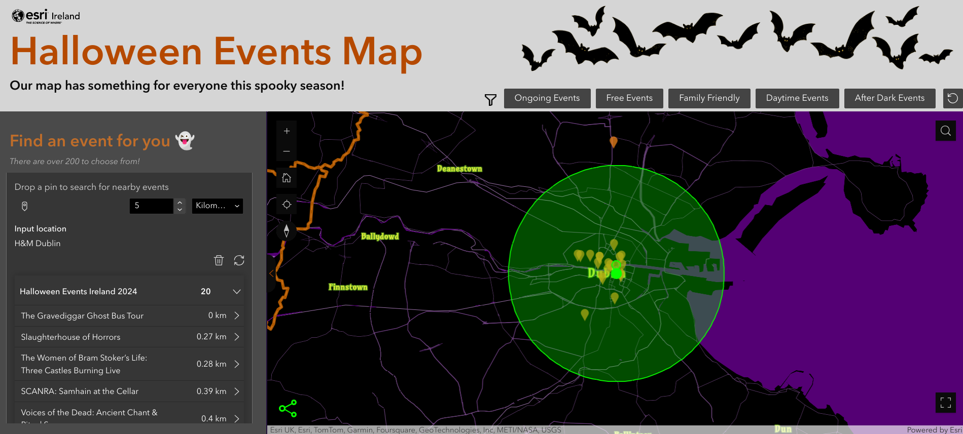
Esri Ireland, the market leader in Geographic Information Systems (GIS), has created a digital map of over 200 frightfully fun festivals and events happening across the island of Ireland this Halloween.

Esri’s ArcGIS digital mapping system was used to create an interactive map which features something for everyone this spooky season. The map details daytime and family-friendly events, as well as events for those who fancy more of a scare.

From creepy campfire tales in Belfast and after-dark jail tours in Cork, to a nightmare on Church Street in Mayo and a ghostly bus tour in Dublin, this map will help ghosts and ghouls of all ages and interests plan their celebrations for Halloween 2024.

Galway County Council digitally maps the heritage of over 25,000 memorials

Esri Ireland, the market leader in geographic information systems (GIS), today announces that Galway County Council has digitally mapped over 25,000 memorials, monuments, and gravestones using Esri’s ArcGIS system. As part of a community-focused project across the county of Galway, Esri’s technology is being used to create a fully digitised process for capturing information about graveyard memorials and making it publicly accessible online.

Throughout Galway, there are 235 council-owned graveyards with ancient monuments and gravestones that provide invaluable insight into family ancestry and social history. Previously, community groups in Galway have endeavoured to capture this culturally significant information, using pen and paper to manually note memorial inscriptions.

Galway County Council’s interactive map, accessed through the Graveyard Memorial Search App, enables volunteers and heritage professionals to view and capture data and images in real-time on their mobile devices. It provides aerial photography of each graveyard, allowing users to zoom into pictorial maps of graveyards on their devices, and accurately identify each gravestone and record data pertaining to it. It also allows citizens to search for burial records and ancestors’ graves, and many graveyards can be explored in 3D, giving people an immersive, realistic experience of visiting family memorials.

The online map provides a streamlined, cloud-based process for collecting, validating, managing and sharing memorial data. It has made the process ten times faster and delivers more accurate and consistent data, which will help to preserve Galway’s graveyard heritage for future generations.

This is leading to increased community engagement, and more than 50 local groups are now using the solution. It is also being used by historians, archaeologists, genealogists and health researchers, as well as schools.

Already, data on over 35 graveyards is available via the app, providing citizens with easy, online access to ancestry information. With over 30 further graveyard surveys planned or in progress, Galway County Council, with support from the Heritage Council, is rapidly expanding the amount of information available via the app. The technology can also be replicated by other county councils and used by all kinds of community groups going forward.

Barry Doyle, GIS Manager, Galway County Council, said: “Simplicity is key to all of this. Everything is done in one efficient, seamless process where the data is stored and accessed centrally in the cloud. With this ArcGIS process we are enabling community groups to achieve their heritage objectives.

Marie Mannion, Heritage Officer, Galway County Council, said: “Digitising Galway’s graveyard heritage has been a powerful way to enable people to learn about the local and national heritage that can be found in graveyards. People can now search for and find photographs of their family’s memorials online and form a stronger connection with their past. It’s an incredible resource for everyone.”

Jack Ffrench, Account Manager, Esri Ireland, said: “Being able to access local heritage, digitally, for Galway citizens has been a really important project to work on and exemplifies the true power of GIS technology. It is rewarding for us to be able to work with local communities, and bringing this important history to life will ensure that Galway’s past can become part of its present. We are looking forward to continuing to work with Galway County Council and seeing how this use case could be repeated within other councils, as well as a wide variety of community groups, in the future.”

National award for innovative Galway Graveyards Mapping Project

Galway County Council has received national recognition for an innovative digital project that mapped over 40,000 graveyard memorial records across County Galway and made them publicly available online.

The ‘Digitising Galway’s Graveyard Heritage’ project was last night (Thursday) named overall winner of the ‘Community Engagement’ category of Esri Ireland’s annual ‘Customer Success Awards’ held in Dublin’s Anantara The Marker Hotel.

Working with and supported by Galway Rural Development, Forum Connemara, The Heritage Council, The National Monuments Service and Galway County Community Archaeology Service, Galway County Council provided funding to local groups to employ experts to train local communities to use mobile technology and to undertake drone mapping of graveyards resulting in a public release of 40,000 records from across the county via the Local Authority’s Open Data Portal.

This is the second national award to be picked up by the project after it was named winner at the Public Sector Digital Transformation Awards last October.

Welcoming the award win, Cllr. Liam Carroll, Cathaoirleach of Galway County Council commented, “The success of the Digital Mapping of Graveyards Project is the result of forensic research and cutting-edge surveying work by the Local Authority’s Heritage department and local communities across Galway. This award win is testament to the innovative nature of the project and its benefit to the diaspora and academia at home and abroad.”

Outlining the background to the project, Barry Doyle, Geographic Information System (GIS) project lead for Galway County Council said, “We have been working with various community groups and organisations to collect and collating valuable data relating to those who are buried in various graveyards for several years.”

“Galway County Council, with funding from the Heritage Council, the Open Data Engagement Fund and its own resources developed and made available a mobile app specifically for use by surveyors at the local level for memorial surveys, along with associated data management and validation processes,” he added. “This technology, along with drone technology, was made available to local community groups to expand the number of graveyards in the project resulting in the 40,000 records that are now publicly available.”

Esri Ireland is the global market leader in GIS and their software is used widely in Ireland in both public and private sector organisations, including most local authorities.

The Galway County Digital Mapping of Graveyards Project may be viewed at galwaycoco.maps.arcgis.com and data.gov.ie.