How Technology Is Improving Safety in Schools

School safety has shifted from reactive measures to proactive, technology-driven systems. Modern institutions are integrating hardware, software, and data analytics to monitor environments, detect risks, and respond to incidents in real time. These systems are designed to address a range of concerns, including unauthorized access, behavioral risks, and environmental hazards.

Technology is now a central component in creating controlled and secure educational environments.

Access Control and Entry Management

Controlling who enters and exits school facilities is a foundational aspect of safety. Traditional methods such as manual sign-ins are being replaced by digital access control systems.

These systems use keycards, biometric authentication, or mobile credentials to regulate entry points. Access permissions can be assigned based on roles, ensuring that only authorized individuals can enter specific areas.

Advanced systems also log entry and exit data, creating a record that can be reviewed if an incident occurs. This improves accountability and enables faster investigations.

Surveillance and Real-Time Monitoring

Video surveillance systems have evolved beyond passive recording. Modern systems incorporate real-time monitoring, motion detection, and automated alerts.

High-resolution cameras combined with analytics software can identify unusual behavior patterns, such as loitering in restricted areas or unauthorized movement during off-hours.

Key capabilities include:

  • Continuous monitoring of high-risk zones
  • Automated alerts triggered by predefined conditions
  • Integration with security personnel for rapid response

These systems provide situational awareness and reduce response times during incidents.

Environmental and Behavioral Detection Systems

Schools are increasingly deploying sensors to detect environmental and behavioral risks. These systems monitor air quality, noise levels, and specific activities that may indicate unsafe conditions.

For example, solutions from providers such as Triton Sensors use advanced detection technology to identify activities like vaping in restricted areas. These systems provide real-time alerts, allowing administrators to intervene quickly.

Detection systems enhance safety by identifying risks that are not visible through traditional monitoring methods.

Emergency Communication and Alert Systems

Effective communication is critical during emergencies. Technology enables schools to broadcast alerts across multiple channels simultaneously.

Mass notification systems can send messages via text, email, and public address systems. These alerts provide instructions and updates during incidents such as lockdowns or evacuations.

Communication systems support:

  • Rapid dissemination of emergency instructions
  • Coordination between staff, students, and first responders
  • Reduction of confusion during critical situations

Reliable communication improves response coordination and safety outcomes.

Data Integration and Centralized Control

Modern safety systems are most effective when integrated into a centralized platform. This allows administrators to monitor multiple systems from a single interface.

Integration combines data from access control, surveillance, and sensor systems. This provides a comprehensive view of the school environment.

Centralized control enables:

  • Faster decision-making based on real-time data
  • Coordinated responses across different safety systems
  • Simplified management of security operations

Unified systems improve efficiency and reduce fragmentation.

Threat Detection Through Analytics

Data analytics is increasingly used to identify potential threats before they escalate. By analyzing patterns in behavior and system data, schools can detect anomalies that may indicate risk.

For example, repeated access attempts to restricted areas or unusual activity patterns can trigger alerts. Predictive analytics allows administrators to take preventive action.

This approach shifts safety management from reactive to proactive.

Cybersecurity and Digital Safety

As schools adopt more digital tools, cybersecurity becomes a critical component of safety. Protecting student data and preventing unauthorized access to systems is essential.

Security measures include encryption, secure authentication, and regular system monitoring. These controls prevent breaches that could compromise sensitive information.

Digital safety ensures that technological systems themselves do not become vulnerabilities.

Staff Training and System Utilization

Technology alone does not ensure safety. Staff must be trained to use systems effectively and respond appropriately to alerts.

Training programs should cover system operation, emergency procedures, and incident reporting. Well-trained staff can interpret data accurately and take timely action.

Effective utilization of technology depends on both system capability and user competence.

Scalability and Adaptability of Safety Systems

School environments change over time, requiring systems that can adapt to new challenges. Scalable solutions allow institutions to expand or modify safety infrastructure as needed.

Modular systems enable incremental upgrades without replacing entire frameworks. This ensures that safety measures remain aligned with evolving requirements.

Adaptability supports long-term effectiveness.

Balancing Safety and Privacy

Implementing safety technology requires careful consideration of privacy concerns. Surveillance and data collection must comply with legal and ethical standards.

Schools must establish clear policies regarding data usage, storage, and access. Transparency helps maintain trust among students, parents, and staff.

Balancing safety and privacy ensures that security measures are both effective and responsible.

Technology is transforming school safety by enabling real-time monitoring, proactive risk detection, and coordinated response systems. From access control to advanced sensor solutions, these tools provide comprehensive protection across multiple dimensions. When integrated effectively and supported by trained staff, technology enhances both safety and operational efficiency in educational environments.

Ring unveils ULTRASTART + AIR – a compact jump starter and inflator

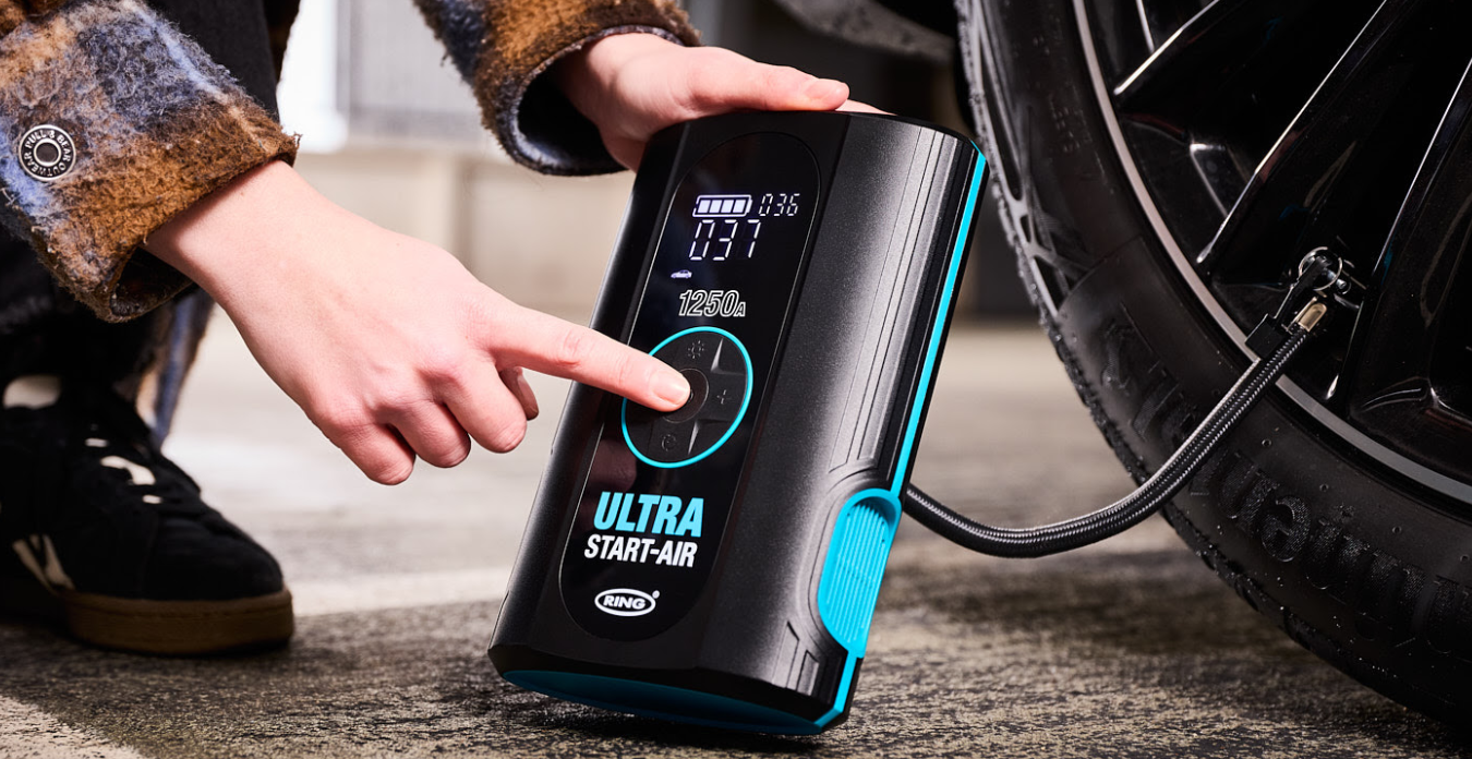
Renowned auto accessory giant, Ring Automotive, has long been dedicated to providing the aftermarket with new and exciting products, and one of its first of 2026 is the ULTRASTART + AIR!

This new product is a powerful, multi‑functional emergency tool combining a jump starter and tyre inflator in one compact unit.

Similar to other products in its portfoilio, this new product from Ring is not limited to being just one piece of equipment, but multiple. The ULTRASTART + AIR is a jump starter, tyre inflator, as well as an LED light and powerbank to ensure the user has everything available to them in an emergency. It is also a compact item that can easily be stored in the glove compartment or anywhere in the vehicle if necessary.

For the jump starter aspect of the tool, its comes with two smart clamps that offer reverse polarity protection and also has a boost function for starting dead batteries. In addition, the ULTRASTART + AIR has integrated hose storage for the tyre inflator element and a storage bag that will hold all of the extra accessories it comes with.

In terms of the engines it can assist with, it’s suitable for up to a six litre petrol and three litre diesel engine. It has a clear display, is easy to use and has an ergonomic body, so is comfortable to hold.

Marketing Director, Henry Bisson, commented: “We are regularly conducting market research on what would be the most helpful to technicians as well as drivers, which is where the ULTRASTART + AIR has come from. Having one piece of equipment that can solve a variety of problems is convenient for all and so, very popular, which is why more of the tools we’re introducing to the market are multi functional.

“The ULTRASTART + AIR is a very powerful tool and due to its suitability for many vehicles, we anticipate this being one of our bestsellers.”

RRP: £100

How do emergency services navigate complex indoor spaces during critical situations?

When smoke fills a stairwell or a crowd surges toward a locked exit, seconds decide outcomes, and indoor navigation becomes as critical as the siren outside. Recent high rise fires, large venue evacuations, and more frequent multi agency drills have pushed emergency services to modernize how they move inside complex sites. The challenge is immediate: GPS weakens indoors, signage disappears in darkness, and even familiar buildings turn hostile when alarms, debris, and panic reshape every corridor.

When every second counts

Could you pick the right stairwell first? Firefighters and paramedics often enter with incomplete information, and they must choose routes quickly while heat, noise, and stress distort judgment. Dispatchers start with pre incident plans, verified access points, known hazards, and on site contact numbers, then they push that package to vehicle terminals and command tablets, so crews do not waste minutes hunting for a service entrance. Teams confirm their entry point on arrival, and they report changes fast, because a locked fire door or a disabled elevator can reroute the entire operation.

Radio remains essential, yet modern responses add structured data so teams do not rely on memory under pressure. Many services conduct surveys before emergencies occur, and they store hydrant locations, standpipe connections, sprinkler control valves, elevator overrides, and rooftop access routes in shared systems that supervisors can update after renovations. Incident commanders assign sectors, track who advances where, and enforce accountability checks at set intervals, because losing a crew inside a maze multiplies risk for everyone.

Maps that work indoors

How do you map a building you cannot see? Indoor mapping platforms convert architectural plans into navigable layers, with rooms, stair cores, restricted zones, and critical equipment marked clearly for operational use, rather than for a glossy brochure. Responders use those layers to plan approach routes, identify alternate exits, and avoid dead ends that trap teams when fire spreads or structural damage blocks corridors. When renovations change layouts, updated mapping prevents crews from sprinting toward a door that no longer exists, and it helps commanders choose safer paths as conditions evolve.

The best tools respect emergency constraints: they load fast, they work offline, and they present simple symbology that stays legible in low light or on a shaking screen. A crew leader can open a floor, tap a stairwell, and share a route to a teammate entering from another side, which keeps teams aligned even when they cannot meet face to face. Platforms such as Visioglobe.com show how indoor maps, routing logic, and searchable points of interest can merge into a single operational view, so navigation stays usable when voice instructions and visibility fail at once.

Finding people fast

What if the victim cannot call out? Locating occupants and responders often depends on indoor positioning, because GPS fades indoors and raw radio signal strength can mislead in steel heavy environments where reflections bounce signals into false confidence. Wi Fi and Bluetooth can estimate location using existing infrastructure, while Ultra Wideband can deliver higher precision in selected zones, and inertial sensors can bridge short gaps when signals drop in stairwells or underground corridors. Agencies rarely bet on one method, and they fuse inputs to stabilize results when smoke, moving crowds, and radio congestion turn clean diagrams into messy reality.

Finding people also means tracking teams, and that is where procedures and devices meet. Some departments use wearable tags or telemetry systems that log entry time, assignment, and last known position, while commanders monitor air supply limits and set check in points that prevent silent drift into danger. Venues can help by sharing live building data, such as elevator outages, access control status, and door sensor alerts, because a locked gate can funnel evacuees into a bottleneck and trap responders behind them.

What venues can do next

Book an indoor mapping and safety audit, then set a budget for updates, device replacement, and drills that keep crews fluent. Prioritize basements, plant rooms, and long corridors, and test offline access during exercises. Look for safety grants, smart city funds, and resilience aid to cover part of the rollout.

Dublin Fire Brigade invests in location intelligence

Esri Ireland, the market leader in Geographic Information Systems (GIS), announces that Dublin Fire Brigade has deployed a new digital mapping system designed to improve emergency response, strengthen firefighter and public safety, and enhance how critical resources are allocated across Dublin city and county.

Ireland’s largest fire and rescue service, Dublin Fire Brigade was founded over 160 years ago. It provides fire, rescue, and emergency ambulance services 24 hours a day, 365 days a year, to Dublin’s 1.5 million citizens. It recently established a new Organisational Intelligence Unit with a key goal to optimise the use of location-based information to effectively manage fire risks and help keep communities safe.

Built using Esri’s ArcGIS technology, the new digital mapping system brings together operational data, such as the locations of fire stations and historic fire incidents, with third-party data – including census and population health information – for the first time.

Enhanced insights support increased safety for both the public and firefighters by raising awareness of buildings in Dublin with fire safety issues – such as inadequate means of escape, building defects, or over-occupancy. Using the technology, Dublin Fire Brigade can now map this information and put effective response plans in place that take known issues into account.

What’s more, the technology is enabling Dublin Fire Brigade to carry out more targeted community fire prevention activities by focusing citizen safety campaigns on specific vulnerable groups, especially in locations that are experiencing clusters of dwelling fires. It can easily see where fire safety efforts are still needed to reach at-risk communities, as well as contextual data such as concentrations of smokers or elderly people.

In addition, Dublin Fire Brigade is using Esri’s ArcGIS technology to identify optimal locations for new fire stations as Dublin continues to expand, as well as to ensure that aerial fire appliances are strategically located to reach the tallest and highest-risk buildings.

Dublin Fire Brigade plans to make the system widely available across varying departments within the organisation to enable more strategic planning and informed decision-making.

Rob Howell, Station Officer, Organisational Intelligence Unit, Dublin Fire Brigade, said: “It has been a really successful collaboration. The consultants at Esri Ireland have a high level of expertise, both in terms of their GIS knowledge and their project management skills. This technology gives us the ability to target our fire prevention strategies – we can deliver campaigns in the right locations to reach the most vulnerable people and have the biggest impact in terms of community fire prevention. Equally, we have to consider firefighters’ health and safety as well as that of the general public and, by being better informed, we can improve our responses to incidents and keep our responders safe in fires and other emergency situations. The potential for location intelligence in the fire service is absolutely huge and has a big role to play in our future.”

Gareth McBride, Customer Success Manager, Esri Ireland, said: “Dublin Fire Brigade is continuously evolving the fire service to meet the needs of Dublin’s residents, businesses, institutions, and visitors. To support this, it is embedding geospatial data intelligence at the heart of operational and strategic decision-making. Location intelligence is helping the fire brigade in managing and reducing fire risks, addressing some of the biggest dangers in a changing cityscape. We are delighted to be working with Dublin Fire Brigade on such an important and necessary project, and excited to see its expanded capabilities as the technology is rolled out more widely.”

River Liffey rescue exercise showcases how drones can support emergency services

A pioneering research and innovation exercise in Dublin has demonstrated how automated drone docking station technology, supported by artificial intelligence, can help first responders deliver faster and more effective search-and-rescue operations in busy urban environments.

The live demonstration, part of a national Drone Innovation Partnership led by Maynooth University in collaboration with Dublin City Council, the Irish Aviation Authority, and Dublin Fire Brigade, simulated a water emergency incident on the River Liffey.

The rescue will be featured in RTÉ One’s new series of Futureville Ireland, which will be broadcast next week to mark Science Week, which begins on Sunday, 9 November.

In the demonstration, Dublin Fire Brigade personnel responded to a report of a person entering the water. An automated drone launched from a remote docking station, autonomously navigated to the scene, and streamed high-resolution data and video to incident command teams. Artificial intelligence tools supported real-time assessment, helping responders rapidly locate the casualty and understand their condition.

By providing critical situational awareness within moments of an emergency call, the drone system enhances response coordination and decision-making — helping first responders make the right decisions faster where every second counts.

Commenting on the exercise, Teresa Hudson, Station Officer, Organisational Intelligence Unit, Dublin Fire Brigade, said: “Drone dockstation technology, properly deployed and operated, will ensure our fire-fighting and rescue teams can respond more efficiently to emergency incidents where time is always critical.

The Drone Innovation Partnership project, which is led by Maynooth University, in close collaboration with Dublin City Council and the Irish Aviation Authority (IAA) is funded through Research Ireland’s LERO Research Centre (Grant 13/RC/2094_P2).

It examines innovative drone technologies, operations, and public-sector applications, building on previous drone traffic management research at Maynooth University as well as Dublin City Council’s Smart City and Drone Strategy initiatives.

Speaking about the research, Principal Investigator Professor Tim McCarthy of Maynooth University, said: “These real-world search-and-rescue exercises allow us to understand both the capabilities and limitations of automated drone networks. This helps us scale AI-enabled emergency response in a structured, responsible, and effective way for the benefit of wider society.”

Enda Walsh, Manager of the UAS (Unmanned Aircraft System) Division at the IAA, said: “This exercise, leveraging both automated UAS and AI, demonstrates how the safe and pragmatic application of these technologies can have significant and positive societal impact. The Drone Innovation Partnership continues to investigate how UAS Ecosystems comprising Drone Regulatory, Technology, Operations, Services and Applications can be rolled out across cities and busy urban environments in a fair, accessible and transparent fashion.

emporia TOUCHsmart.3 Review

The emporia TOUCHsmart.3 is not a flagship smartphone, nor is it a basic “talk and text” feature phone. It carves out a unique and necessary niche: a clamshell (flip) phone that combines the simplicity and tactile feel of a physical keyboard with the modern connectivity required today, primarily instant messaging and flip phones are back with a bang and this one looks nice and is well built only the front display could have had some use but not this time.

It is clearly targeted at the senior market or those seeking a “dumbphone” experience who still need essential smart features like WhatsApp which is like other massaging apps more commonly used now and a growing trend with senior users of smartphones.

The TOUCHsmart.3 is built around a “best-of-both-worlds” design philosophy, blending hardware and software elements for maximum accessibility.

The most distinguishing factor is the flip design coupled with dual input:

  1. Physical Keypad: Features large, clearly labeled keys that are easy to press, making dialing and basic texting straightforward.
  2. Touchscreen: The internal 3.47-inch display is a full touchscreen, allowing users to navigate apps like WhatsApp and maps just like a small smartphone, you would be forgiven to forget it is actually a touch screen which I forgot several times but its cool and you should avail of it.

This combination addresses the common frustration of needing a full keyboard for dialing but a touchscreen for modern app interaction. Flipping open the phone also automatically answers a call like the good oul days with flip phones.

Unlike many basic feature phones, the TOUCHsmart.3 supports 4G LTE, Wi-Fi, and Bluetooth 5.0. Crucially, it runs on a simplified Android OS, giving it the power to run essential modern communication apps.

Emporia highlights the dedicated shortcut key for messaging (WhatsApp, Signal, or Telegram), recognizing that staying in touch often means more than just SMS and voice calls.

Yays

  • Ease of Use: The large buttons and the charging cradle are highly praised by the target audience (seniors).
  • SOS Function: The dedicated emergency button offers peace of mind by contacting up to five designated contacts instantly which is a key USP with emporia devices all round
  • Build Quality: It has an IP44 rating and generally feels sturdy and well-built.
  • Accessibility: Hearing aid compatibility (M4/T4) is a thoughtful inclusion.

Nays

  • Performance: The hardware (2GB RAM, MediaTek P35) can lead to some lagging especially when using complex apps or trying to multitask but this device is not targetted at such a user but tested anyway.
  • Battery Life: The 1,400 mAh battery capacity is relatively small for an Android-based device, possibly needing to charge it daily, particularly if using messaging apps frequently.
  • Limited Customization: Being an adapted Android device, it can be restrictive in accessing deeper settings or using alternative launchers.
  • Internal Storage: The 16GB internal memory is limited, although it is expandable up to 64GB via MicroSD.
  • Camera Quality: The 8 MP main camera is functional but delivers only basic photo quality, which is typical for a device in this segment but perfoms well in daytime scenarios.

The emporia TOUCHsmart.3 is an excellent choice for a very specific user: someone who values the tangible simplicity of a flip phone and physical buttons but cannot live without a key messaging app like WhatsApp to stay connected with family.

It’s the ultimate compromise phone—less complex than a full smartphone, but far more connected than a standard feature phone.

If your priority is simplicity, ease of calling/texting, safety, and a dedicated WhatsApp button, the TOUCHsmart.3 is a highly recommendable device.

However, if you require a phone for heavy internet browsing, demanding apps, long-lasting battery life without daily charging, or taking high-quality photos, you might find the performance and battery limitations frustrating but previous flip phone users of old will feel comfortable as they where the same before and again aimed at a targt demographic.


Image and Video samples day and night front and rear cameras


Features

  • Simple and Convenient: With pre-installed WhatsApp, you can easily chat with family and friends, share photos or send voice messages – without any complicated settings. Stay in touch with your loved ones with ease.
  • Your Everyday Smart Companion: Large physical keys, a bright color touchscreen, and intuitive navigation make it extremely easy to use – perfect for those looking for a hassle-free mobile experience.
  • One-Touch Security: The built-in emergency button allows up to five contacts to be alerted with a single press – for quick and efficient assistance when needed.
  • Exceptional Sound Quality: Extra-loud ringtone, loud speakers, and hearing aid compatibility ensure you won’t miss a call and hear every conversation clearly.
  • Convenient Charging – No More Bulky Cables: The included charging dock makes charging a breeze – just put the phone on its stand, and it charges automatically. No more fiddling with cables.

BUY

Unboxing and walkthrough

Other emporia reviews 


How Technology Helps When Life Takes an Unexpected Turn on the Road

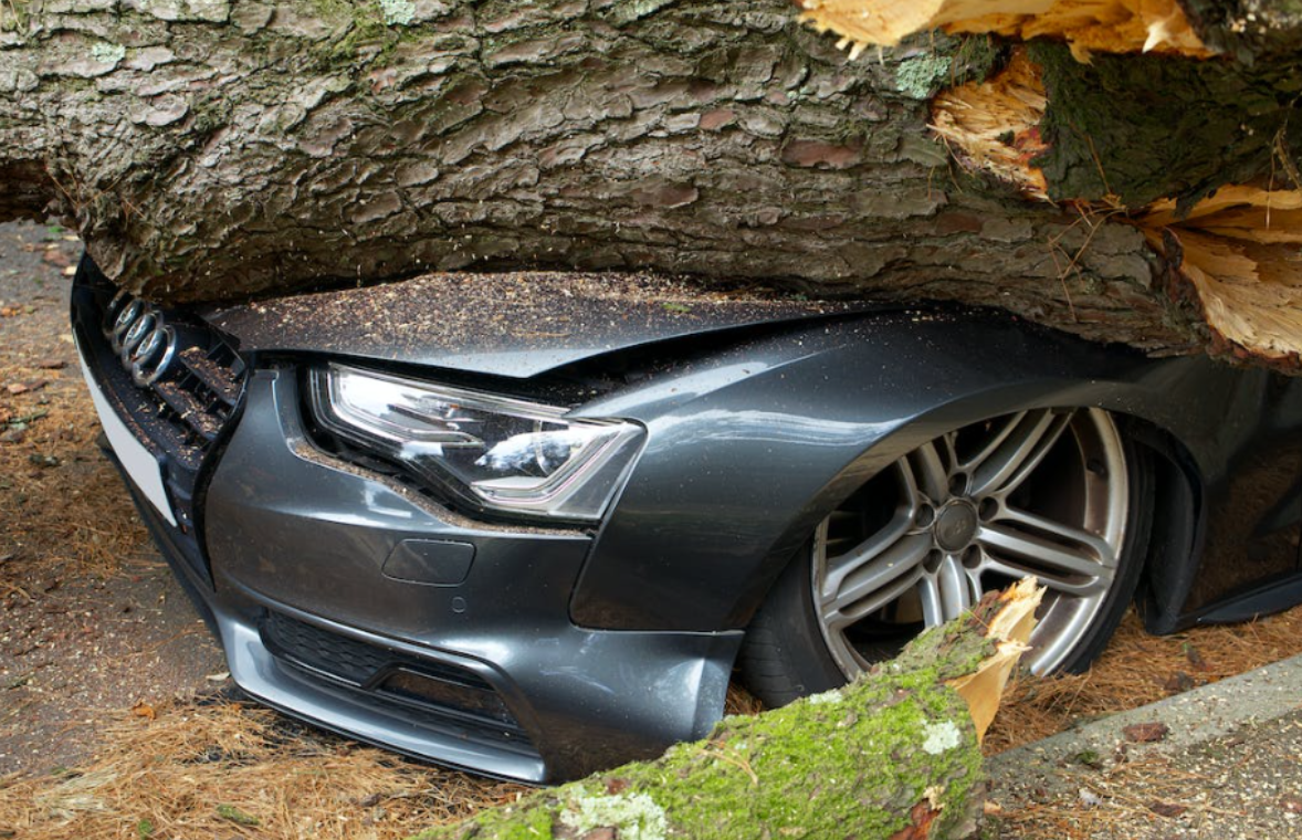
Car accidents can change lives in an instant. What begins as a routine drive can quickly turn into chaos, confusion, and pain. When the unexpected happens, it leaves people shaken and searching for answers. The moments after a collision are crucial, as the right help arriving quickly can make a difference between recovery and tragedy. Fortunately, technology is playing a bigger role than ever in improving outcomes in these critical situations.

Modern vehicles and connected devices are designed to detect accidents and automatically summon help. This means that even if someone is unable to call for aid themselves, emergency services can be alerted immediately. Technology has stepped in to fill the gap during these vulnerable moments. By shrinking the time between accident and response, these tools improve survival chances and ease the strain on victims and their families.

While technology cannot prevent every accident, it provides comfort and support when life takes a sharp turn. Drivers can feel more secure knowing that help is available through their cars or personal devices. These innovations create a safety net, catching people when they fall and guiding them through what can be the darkest hours of their lives.

The Role Technology Plays in Car Accidents

According to a law firm, car accidents remain one of the leading causes of injury and death worldwide. Many advances in automotive technology aim to reduce the number and severity of collisions. Features such as collision avoidance systems, automatic braking, lane departure warnings, and adaptive cruise control are increasingly standard in new vehicles. These tools act as extra eyes and brakes, alerting drivers to danger and sometimes preventing crashes altogether.

When accidents do happen, vehicles equipped with emergency response systems can send alerts directly to first responders. These systems share location and crash severity information, helping emergency personnel arrive faster and better prepared. Additionally, smartphone apps can detect collisions and notify contacts automatically, connecting victims to support even if they are incapacitated.

The integration of technology in accident management continues to grow. Data gathered from crash events helps improve safety designs and emergency procedures. Over time, this creates safer roads and more effective responses. Though no technology can eliminate all risks, it strengthens the chain of survival from the moment of impact onward.

How Smart Devices Change Emergency Responses

Smart devices such as wearables and voice assistants contribute significantly to emergency management after car accidents. Smartwatches, for example, can sense falls or sudden impacts and automatically place calls to emergency services. They also monitor vital signs, providing responders with early information about a person’s condition.

Inside vehicles, voice-activated assistants allow drivers and passengers to call for help hands-free, reducing delays caused by shock or injury. Connected car systems can transmit real-time data to emergency teams, including seatbelt usage, airbag deployment, and crash location. This detailed information shapes a faster, more targeted response.

The ability of smart devices to link individuals with help has saved countless lives. As technology advances, this connection becomes more seamless and reliable. Emergency responders gain valuable tools that improve situational awareness and outcomes. For victims, knowing that technology is ready to assist provides peace of mind, even in the face of unexpected disaster.

Technology That Supports Recovery

The assistance technology offers extends beyond the accident itself. Recovery from injury often involves navigating complex medical and administrative processes. Digital tools streamline communication with healthcare providers and simplify the management of appointments, medications, and therapies.

Telemedicine has become a vital part of post-accident care, allowing patients to consult with doctors remotely. This reduces the need for travel, which can be difficult for those with mobility challenges. Apps designed to track symptoms and progress help individuals stay engaged in their recovery and communicate changes quickly to caregivers.

Additionally, technology aids in insurance claims and legal matters that arise after accidents. Online platforms make submitting documents and tracking cases more efficient. This reduces frustration and allows injured parties to focus on healing rather than paperwork. Overall, technology transforms the recovery experience, making it more manageable and less isolating.

Challenges and Cautions with Tech in Emergencies

While technology offers many benefits, it is not without limitations. Emergency systems depend on power and connectivity, which may not always be available. In remote areas or during power outages, devices may fail to function when they are needed most. Backup plans and personal preparedness remain essential.

Technical errors or malfunctions can cause delays or false alarms. It is important for users to maintain devices properly and stay informed about updates or recalls. Overreliance on technology can lead to complacency, so human awareness and caution on the road continue to be vital.

Privacy concerns arise with the data collected by emergency technologies. Personal information such as location, health data, and crash details may be shared with multiple parties. Understanding how this data is protected and used helps maintain trust and control. Users should review privacy policies and manage settings to safeguard their information.

Looking Ahead with Technology and Safety

The future of technology in road safety promises exciting advancements. Autonomous vehicles, improved sensor arrays, and faster communication networks will further reduce accident rates and improve emergency responses. As cars become smarter, their ability to prevent crashes and protect occupants grows.

Drivers and passengers will continue to benefit from innovations that combine human skill with machine assistance. Staying informed about new technologies and integrating them responsibly into daily life will enhance safety on the road. Technology is not a replacement for caution but a powerful partner in managing the unpredictability of driving.

With ongoing progress, fewer people will face the trauma of accidents, and those who do will find help arriving faster and care improving. The promise of technology lies in turning moments of crisis into opportunities for recovery and resilience.


Vodafone Ireland partners with the OGCIO to trial next-generation communications technology for emergency services

Vodafone Ireland has partnered with The Office of the Government CIO (OGCIO), within the Department of Public Expenditure and Reform, to trial next-generation communications technology to transform emergency services in Ireland.

The new technology is being showcased this week at an international event in Co. Mayo, attended by both Irish and International Public Protection Disaster Relief (PPDR) agencies, including An Garda Siochana, the Irish Coast Guard, Irish fire services, civil defence, Revenue (Customs Service) and the HSE/National Ambulance Service.

The event is supported by the Department of Rural and Community Development and the Gaeltacht and Mayo County Council.

Next-generation Mission Critical Communications Technology 

Vodafone Ireland’s Mission Critical Communications (MCx) network is the first of its kind for PPDR agencies in Ireland. Built specifically for emergency responders, MCx provides priority access on mobile networks, enabling teams to talk, share data, and coordinate instantly – even when networks are congested.

This marks a major step in moving from legacy voice and text services to secure, high-performance digital tools, in line with international standards for PPDR communications.

Vodafone Ireland’s solution will combine roaming on its national 4G and 5G networks with direct-to-device satellite connectivity in the future. This will allow anyone, on any network, to reach 112 or 999 during emergencies, even in remote or weather-affected areas. Similarly, in the future, PPDR agencies will be able to access direct to device satellite when mobile networks are unavailable.

Westport Event

The Westport event features a proof-of-concept trial of the new technology. Over two days, staged simulations will replicate complex, evolving incidents, training first responders on new communication capabilities while testing interoperability and operation procedures across multiple agencies.

Participants include local agencies such as Mayo Fire, Mayo County Council Emergency Plan, Public Health Nurse, and local GP, alongside international experts and PPDR representatives from Scotland, Iceland, Norway and Sweden.

The trial builds on Vodafone’s critical national infrastructure network, with government agencies now able to access Vodafone’s 4G/5G network via roaming services. This opens the door to cross-border cooperation, enabling European PPDR agencies to coordinate more effectively during international emergencies.

Strategic Importance

The trial is being observed by European PPDR agencies and European Commission department DG HOME’s EuCCs initiative as part of broader efforts to establish a pan-European mission-critical communications platform, enhancing cross-border emergency communications.

A key highlight of the event includes a situational reenactment of the MV Matthew interdiction in Cork (2023), demonstrating how enhanced communications can improve situational awareness, operational efficiencies, and response times. Several of those involved in the original operation are contributing their experience and insights to the exercise.

Comments

Minister for Public Expenditure, Infrastructure, Public Service Reform and Digitalisation Jack Chambers said: “This trial is a vital pillar of Ireland’s digital transformation, and a crucial step forward for our emergency services and emergency management. It demonstrates how intergovernmental collaboration between the Department of Public Expenditure and Reform, the Office of the Government CIO, and partners like Vodafone is driving innovation in public safety. By modernising our emergency communications infrastructure, we’re ensuring that first responders have access to secure, high-performance tools that will save lives and strengthen community resilience.”


Sabrina Casalta, CEO Vodafone Ireland said: “Ireland is showing real leadership in how we modernise emergency communications. This trial is not just a milestone for Vodafone Ireland and the Irish Government; it marks the first time a mission critical communications system of this kind has been deployed in Ireland. It is proof that we are leading the way in Europe by building resilient, future-proof systems for public protection and disaster relief. We’re proud to partner with the OGCIO to deliver trusted connectivity in innovation that will save lives.”


Sheila Kavanagh, Network Director, Vodafone Ireland said: “Vodafone has been supporting the build out of the Irish Government’s National Low Latency Platform for the past three years using our fibre network. We are delighted to build upon this work by enabling national roaming for PPDR agencies on our mobile network through Vodafone Roaming Services. Crucially, Vodafone Ireland can integrate our direct to device satellite technology as part of our NLLP strategy in the future, delivering the reliability our first responders need from a communications platform.”

emporia Smart7.Lite and Smart.ME7 First Look

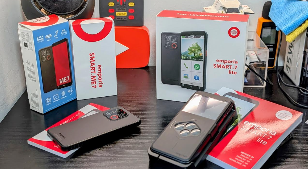
Each new 7 Series model – the Smart7.Lite, and Smart.ME7 – comes with a user-replaceable battery with a standby time of almost 10 days. The battery has been tested for at least 1,000 charging cycles and the charging capacity can be limited to 80 per cent to ensure longevity and we will be taking two of the models for a test over the coming weeks and will have a full review soon so check the unboxing below and if you need anything answered you know what to do..

In addition, spare parts for the 7 Series are guaranteed to be available for at least seven years, plus there is a guaranteed five-generation Android upgrade path. The three models will ship with Android 15, with an update to the newly announced Android 16 due in early 2026.

“Our customers are not mobile phone hoppers who buy a new smartphone every year or two, which is why we have designed the new 7 series with durability in mind”, explains emporia marketing director, Karin Schaumberger.

Security in mind

Thanks to NFC and a fingerprint sensor, users don’t have to worry when banking online or logging into digital government services. emporia also prioritizes the implementation of Android security patches; 7 Series smartphones will be automatically updated to the latest security level.

“Security is a key selling point for our customers, and there can be no compromises in this regard,” explains Karin Schaumberger.

With personal security in mind, 7 Series smartphones feature emporia’s signature ‘No Panic’ button – an external, directly accessible button so you can more easily call for help in an emergency. The button can alternatively be configured as a shortcut to a favourite function – for example, offering instant access to the Google Gemini voice assistant.

Enhanced usability

The new 7 Series can be used in standard Android mode or with the streamlined emporia interface, which makes it easier to find and use core functionality including calls, emails and favourite apps. The emporia Info Centre collates all notifications from multiple sources – from emails and WhatsApp messages to calendar or voicemail alerts – so you can catch up with a single glance.

Also on board is the new Flash Notification option, which means you’ll never miss a call or message again when your phone is on silent. Incoming calls and messages are signalled by both the screen and backlight flashing.

To help simplify things further still, the free emporiaCOACH app helps digital newcomers and switchers to quickly familiarise themselves with their smartphone.

Compact format

The 7 Series comes in a pocket-friendly 5.45in format; there will be no 6.6in option as in previous ranges.  Each model features a triple-lens camera plus selfie camera.

“The demand for more manageable smartphones remains strong, and the feedback from our customers is clear,” explains Karin Schaumberger.

Model differences – all about the extras

All new 7 Series models include the core functionality detailed above. The difference come in the extras supplied with each model.

Smart7.Lite  – £250/€250 The bestseller comes as standard with emporia’s patented Smartcover, which allows key functions to be used even while closed. It offers slimline protection for both screen and casing. It also comes with a handy docking cradle, which cuts cable-clutter when charging but also provides a nicely angled hands-free calling hub.

Smart7.Mini  – £200/€200 Comes with the docking cradle as standard, but not the Smartcover.

Smart.ME7 – £200/€200 Supports full Android mainstream; no extras supplied as standard.

Availability

The emporia 7 Series will be available to buy this month, from stockists including Amazon.

See our emporia reviews

First look video